You are here: Home > Network List > US - United States National Seismic Network Stations List
> Station WUAZ Wupatki, Arizona, USA > Earthquake Result Viewer
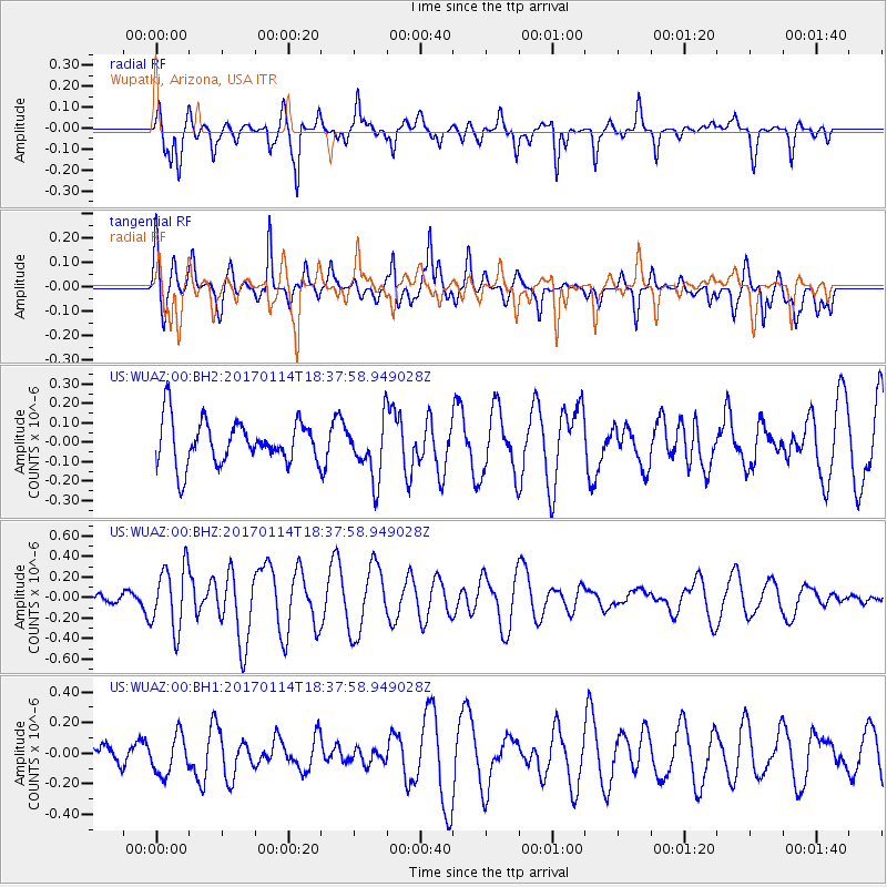
WUAZ Wupatki, Arizona, USA - Earthquake Result Viewer
*The percent match for this event was below the threshold and hence no stack was calculated.
| Earthquake location: |
Fiji Islands Region |
| Earthquake latitude/longitude: |
-18.7/176.1 |
| Earthquake time(UTC): |
2017/01/14 (014) 18:25:43 GMT |
| Earthquake Depth: |
4.6 km |
| Earthquake Magnitude: |
5.7 Mww |
| Earthquake Catalog/Contributor: |
NEIC PDE/us |
|
| Network: |
US United States National Seismic Network |
| Station: |
WUAZ Wupatki, Arizona, USA |
| Lat/Lon: |
35.52 N/111.37 W |
| Elevation: |
1592 m |
|
| Distance: |
87.2 deg |
| Az: |
51.177 deg |
| Baz: |
244.886 deg |
| Ray Param: |
$rayparam |
*The percent match for this event was below the threshold and hence was not used in the summary stack. |
|
| Radial Match: |
74.96176 % |
| Radial Bump: |
370 |
| Transverse Match: |
59.736343 % |
| Transverse Bump: |
352 |
| SOD ConfigId: |
1943534 |
| Insert Time: |
2017-01-28 18:28:08.511 +0000 |
| GWidth: |
2.5 |
| Max Bumps: |
400 |
| Tol: |
0.001 |
|
Signal To Noise
| Channel | StoN | STA | LTA |
| US:WUAZ:00:BHZ:20170114T18:37:58.949028Z | 4.776025 | 3.086021E-7 | 6.4614845E-8 |
| US:WUAZ:00:BH1:20170114T18:37:58.949028Z | 1.2909126 | 1.2847154E-7 | 9.951993E-8 |
| US:WUAZ:00:BH2:20170114T18:37:58.949028Z | 1.3513811 | 1.5182569E-7 | 1.1234853E-7 |
| Arrivals |
| Ps | |
| PpPs | |
| PsPs/PpSs | |


