You are here: Home > Network List > TA - USArray Transportable Network (new EarthScope stations) Stations List
> Station D23K Nanushuk River, AK USA > Earthquake Result Viewer
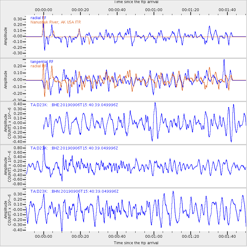
D23K Nanushuk River, AK USA - Earthquake Result Viewer
*The percent match for this event was below the threshold and hence no stack was calculated.
| Earthquake location: |
Loyalty Islands |
| Earthquake latitude/longitude: |
-20.2/169.0 |
| Earthquake time(UTC): |
2019/09/06 (249) 15:27:57 GMT |
| Earthquake Depth: |
26 km |
| Earthquake Magnitude: |
5.8 Mww |
| Earthquake Catalog/Contributor: |
NEIC PDE/us |
|
| Network: |
TA USArray Transportable Network (new EarthScope stations) |
| Station: |
D23K Nanushuk River, AK USA |
| Lat/Lon: |
68.97 N/150.68 W |
| Elevation: |
406 m |
|
| Distance: |
93.5 deg |
| Az: |
13.537 deg |
| Baz: |
217.521 deg |
| Ray Param: |
$rayparam |
*The percent match for this event was below the threshold and hence was not used in the summary stack. |
|
| Radial Match: |
59.946682 % |
| Radial Bump: |
400 |
| Transverse Match: |
66.61949 % |
| Transverse Bump: |
400 |
| SOD ConfigId: |
19053131 |
| Insert Time: |
2019-09-20 15:34:30.148 +0000 |
| GWidth: |
2.5 |
| Max Bumps: |
400 |
| Tol: |
0.001 |
|
Signal To Noise
| Channel | StoN | STA | LTA |
| TA:D23K: :BHZ:20190906T15:40:39.049996Z | 2.8892272 | 3.480931E-7 | 1.2047965E-7 |
| TA:D23K: :BHN:20190906T15:40:39.049996Z | 1.4139352 | 1.5472338E-7 | 1.09427496E-7 |
| TA:D23K: :BHE:20190906T15:40:39.049996Z | 0.758116 | 9.84782E-8 | 1.298986E-7 |
| Arrivals |
| Ps | |
| PpPs | |
| PsPs/PpSs | |


