You are here: Home > Network List > TA - USArray Transportable Network (new EarthScope stations) Stations List
> Station N16K Nishlik Lake, AK, USA > Earthquake Result Viewer
N16K Nishlik Lake, AK, USA - Earthquake Result Viewer
| Earthquake location: |
Loyalty Islands |
| Earthquake latitude/longitude: |
-20.2/169.0 |
| Earthquake time(UTC): |
2019/09/06 (249) 15:27:57 GMT |
| Earthquake Depth: |
26 km |
| Earthquake Magnitude: |
5.8 Mww |
| Earthquake Catalog/Contributor: |
NEIC PDE/us |
|
| Network: |
TA USArray Transportable Network (new EarthScope stations) |
| Station: |
N16K Nishlik Lake, AK, USA |
| Lat/Lon: |
60.47 N/158.77 W |
| Elevation: |
582 m |
|
| Distance: |
84.5 deg |
| Az: |
15.393 deg |
| Baz: |
210.226 deg |
| Ray Param: |
0.04540682 |
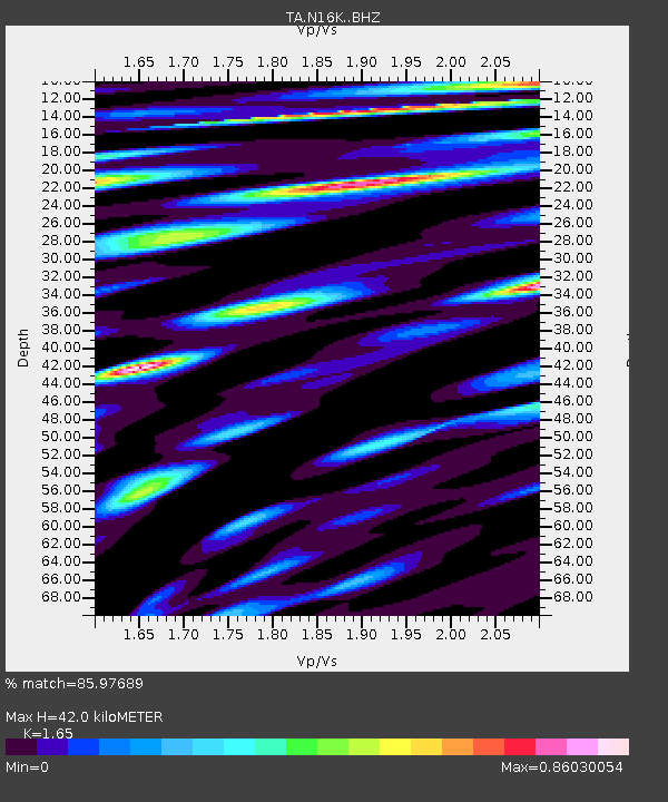
| Estimated Moho Depth: |
42.0 km |
| Estimated Crust Vp/Vs: |
1.65 |
| Assumed Crust Vp: |
6.276 km/s |
| Estimated Crust Vs: |
3.804 km/s |
| Estimated Crust Poisson's Ratio: |
0.21 |
|
| Radial Match: |
85.97689 % |
| Radial Bump: |
400 |
| Transverse Match: |
72.94038 % |
| Transverse Bump: |
400 |
| SOD ConfigId: |
19053131 |
| Insert Time: |
2019-09-20 15:35:15.716 +0000 |
| GWidth: |
2.5 |
| Max Bumps: |
400 |
| Tol: |
0.001 |
|

Signal To Noise
| Channel | StoN | STA | LTA |
| TA:N16K: :BHZ:20190906T15:39:56.375008Z | 5.331979 | 1.0680128E-6 | 2.0030328E-7 |
| TA:N16K: :BHN:20190906T15:39:56.375008Z | 2.3032565 | 3.7078178E-7 | 1.6098154E-7 |
| TA:N16K: :BHE:20190906T15:39:56.375008Z | 1.8969107 | 3.0504793E-7 | 1.6081302E-7 |
| Arrivals |
| Ps | 4.5 SECOND |
| PpPs | 17 SECOND |
| PsPs/PpSs | 22 SECOND |


