You are here: Home > Network List > TA - USArray Transportable Network (new EarthScope stations) Stations List
> Station P18K Big Mountain, AK, USA > Earthquake Result Viewer
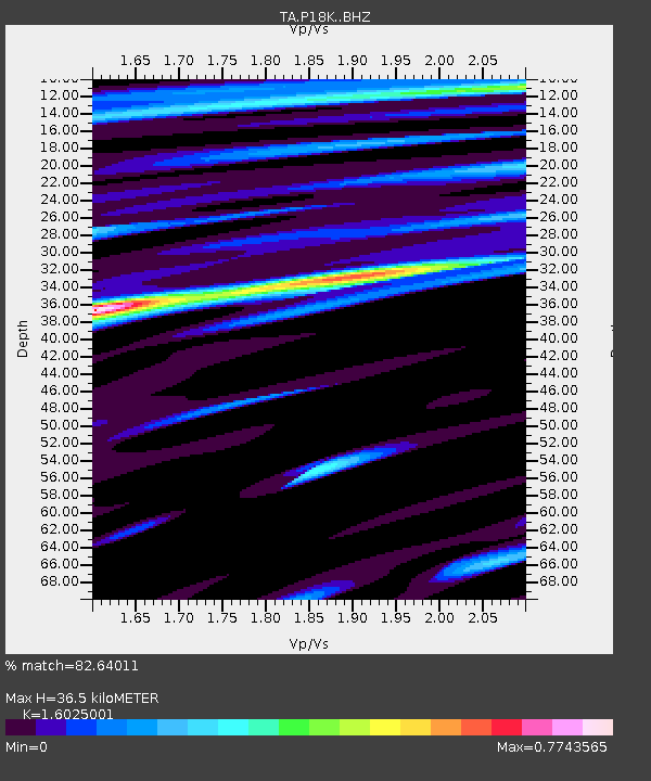
P18K Big Mountain, AK, USA - Earthquake Result Viewer
| Earthquake location: |
Loyalty Islands |
| Earthquake latitude/longitude: |
-20.2/169.0 |
| Earthquake time(UTC): |
2019/09/06 (249) 15:27:57 GMT |
| Earthquake Depth: |
26 km |
| Earthquake Magnitude: |
5.8 Mww |
| Earthquake Catalog/Contributor: |
NEIC PDE/us |
|
| Network: |
TA USArray Transportable Network (new EarthScope stations) |
| Station: |
P18K Big Mountain, AK, USA |
| Lat/Lon: |
59.39 N/155.23 W |
| Elevation: |
680 m |
|
| Distance: |
84.5 deg |
| Az: |
17.489 deg |
| Baz: |
213.486 deg |
| Ray Param: |
0.04539321 |
| Estimated Moho Depth: |
36.5 km |
| Estimated Crust Vp/Vs: |
1.60 |
| Assumed Crust Vp: |
6.438 km/s |
| Estimated Crust Vs: |
4.018 km/s |
| Estimated Crust Poisson's Ratio: |
0.18 |
|
| Radial Match: |
82.64011 % |
| Radial Bump: |
400 |
| Transverse Match: |
71.64681 % |
| Transverse Bump: |
400 |
| SOD ConfigId: |
19053131 |
| Insert Time: |
2019-09-20 15:35:23.864 +0000 |
| GWidth: |
2.5 |
| Max Bumps: |
400 |
| Tol: |
0.001 |
|

Signal To Noise
| Channel | StoN | STA | LTA |
| TA:P18K: :BHZ:20190906T15:39:56.474984Z | 7.4425488 | 9.01496E-7 | 1.2112731E-7 |
| TA:P18K: :BHN:20190906T15:39:56.474984Z | 1.7952521 | 2.8773502E-7 | 1.6027555E-7 |
| TA:P18K: :BHE:20190906T15:39:56.474984Z | 2.158721 | 1.6449557E-7 | 7.620048E-8 |
| Arrivals |
| Ps | 3.5 SECOND |
| PpPs | 14 SECOND |
| PsPs/PpSs | 18 SECOND |


