You are here: Home > Network List > TS - TERRAscope (Southern California Seismic Network) Stations List
> Station MLAC Mammoth Lakes, California, USA > Earthquake Result Viewer
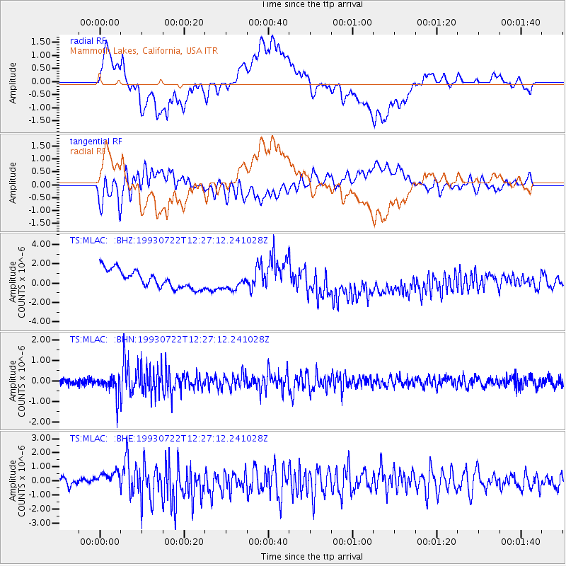
MLAC Mammoth Lakes, California, USA - Earthquake Result Viewer
*The percent match for this event was below the threshold and hence no stack was calculated.
| Earthquake location: |
Mariana Islands Region |
| Earthquake latitude/longitude: |
21.8/144.2 |
| Earthquake time(UTC): |
1993/07/22 (203) 12:15:36 GMT |
| Earthquake Depth: |
126 km |
| Earthquake Magnitude: |
5.5 MB, 5.8 UNKNOWN |
| Earthquake Catalog/Contributor: |
WHDF/NEIC |
|
| Network: |
TS TERRAscope (Southern California Seismic Network) |
| Station: |
MLAC Mammoth Lakes, California, USA |
| Lat/Lon: |
37.63 N/118.83 W |
| Elevation: |
2170 m |
|
| Distance: |
82.3 deg |
| Az: |
52.688 deg |
| Baz: |
291.379 deg |
| Ray Param: |
$rayparam |
*The percent match for this event was below the threshold and hence was not used in the summary stack. |
|
| Radial Match: |
59.22648 % |
| Radial Bump: |
400 |
| Transverse Match: |
57.24187 % |
| Transverse Bump: |
400 |
| SOD ConfigId: |
4480 |
| Insert Time: |
2010-02-26 14:28:26.808 +0000 |
| GWidth: |
2.5 |
| Max Bumps: |
400 |
| Tol: |
0.001 |
|
Signal To Noise
| Channel | StoN | STA | LTA |
| TS:MLAC: :BHN:19930722T12:27:12.241028Z | 3.2902126 | 4.9312047E-7 | 1.4987495E-7 |
| TS:MLAC: :BHE:19930722T12:27:12.241028Z | 0.9191581 | 4.2906285E-7 | 4.667998E-7 |
| TS:MLAC: :BHZ:19930722T12:27:12.241028Z | 0.8811999 | 8.114519E-7 | 9.2084883E-7 |
| Arrivals |
| Ps | |
| PpPs | |
| PsPs/PpSs | |


