You are here: Home > Network List > II - Global Seismograph Network (GSN - IRIS/IDA) Stations List
> Station WRAB Tennant Creek, NT, Australia > Earthquake Result Viewer
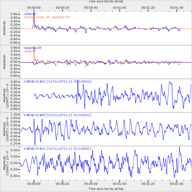
WRAB Tennant Creek, NT, Australia - Earthquake Result Viewer
*The percent match for this event was below the threshold and hence no stack was calculated.
| Earthquake location: |
Vanuatu Islands |
| Earthquake latitude/longitude: |
-13.7/166.4 |
| Earthquake time(UTC): |
2017/01/16 (016) 01:16:38 GMT |
| Earthquake Depth: |
10 km |
| Earthquake Magnitude: |
5.8 mb |
| Earthquake Catalog/Contributor: |
NEIC PDE/us |
|
| Network: |
II Global Seismograph Network (GSN - IRIS/IDA) |
| Station: |
WRAB Tennant Creek, NT, Australia |
| Lat/Lon: |
19.93 S/134.36 E |
| Elevation: |
366 m |
|
| Distance: |
31.2 deg |
| Az: |
254.078 deg |
| Baz: |
83.514 deg |
| Ray Param: |
$rayparam |
*The percent match for this event was below the threshold and hence was not used in the summary stack. |
|
| Radial Match: |
76.32053 % |
| Radial Bump: |
398 |
| Transverse Match: |
63.42558 % |
| Transverse Bump: |
400 |
| SOD ConfigId: |
1943534 |
| Insert Time: |
2017-01-30 01:17:50.805 +0000 |
| GWidth: |
2.5 |
| Max Bumps: |
400 |
| Tol: |
0.001 |
|
Signal To Noise
| Channel | StoN | STA | LTA |
| II:WRAB:00:BHZ:20170116T01:22:28.018992Z | 2.4010255 | 4.8444167E-7 | 2.0176448E-7 |
| II:WRAB:00:BH1:20170116T01:22:28.018992Z | 1.5630035 | 1.5861927E-7 | 1.0148363E-7 |
| II:WRAB:00:BH2:20170116T01:22:28.018992Z | 4.190429 | 3.2243165E-7 | 7.694478E-8 |
| Arrivals |
| Ps | |
| PpPs | |
| PsPs/PpSs | |


