You are here: Home > Network List > US - United States National Seismic Network Stations List
> Station MSO Missoula, Montana, USA > Earthquake Result Viewer
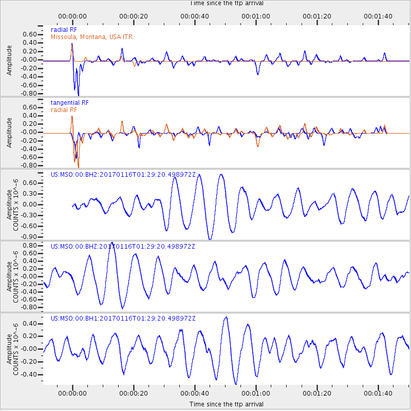
MSO Missoula, Montana, USA - Earthquake Result Viewer
*The percent match for this event was below the threshold and hence no stack was calculated.
| Earthquake location: |
Vanuatu Islands |
| Earthquake latitude/longitude: |
-13.7/166.4 |
| Earthquake time(UTC): |
2017/01/16 (016) 01:16:38 GMT |
| Earthquake Depth: |
10 km |
| Earthquake Magnitude: |
5.8 mb |
| Earthquake Catalog/Contributor: |
NEIC PDE/us |
|
| Network: |
US United States National Seismic Network |
| Station: |
MSO Missoula, Montana, USA |
| Lat/Lon: |
46.83 N/113.94 W |
| Elevation: |
1264 m |
|
| Distance: |
92.9 deg |
| Az: |
42.562 deg |
| Baz: |
253.257 deg |
| Ray Param: |
$rayparam |
*The percent match for this event was below the threshold and hence was not used in the summary stack. |
|
| Radial Match: |
65.778595 % |
| Radial Bump: |
400 |
| Transverse Match: |
80.76355 % |
| Transverse Bump: |
400 |
| SOD ConfigId: |
1943534 |
| Insert Time: |
2017-01-30 01:18:45.489 +0000 |
| GWidth: |
2.5 |
| Max Bumps: |
400 |
| Tol: |
0.001 |
|
Signal To Noise
| Channel | StoN | STA | LTA |
| US:MSO:00:BHZ:20170116T01:29:20.498972Z | 0.99851763 | 2.6835278E-7 | 2.6875117E-7 |
| US:MSO:00:BH1:20170116T01:29:20.498972Z | 0.54311574 | 7.895604E-8 | 1.4537608E-7 |
| US:MSO:00:BH2:20170116T01:29:20.498972Z | 3.7843647 | 5.3296174E-7 | 1.4083255E-7 |
| Arrivals |
| Ps | |
| PpPs | |
| PsPs/PpSs | |


