You are here: Home > Network List > TS - TERRAscope (Southern California Seismic Network) Stations List
> Station MLAC Mammoth Lakes, California, USA > Earthquake Result Viewer
MLAC Mammoth Lakes, California, USA - Earthquake Result Viewer
*The percent match for this event was below the threshold and hence no stack was calculated.
| Earthquake location: |
South Of Fiji Islands |
| Earthquake latitude/longitude: |
-23.9/179.8 |
| Earthquake time(UTC): |
1993/08/07 (219) 17:53:27 GMT |
| Earthquake Depth: |
555 km |
| Earthquake Magnitude: |
6.0 MB, 5.9 UNKNOWN, 6.9 MW |
| Earthquake Catalog/Contributor: |
WHDF/NEIC |
|
| Network: |
TS TERRAscope (Southern California Seismic Network) |
| Station: |
MLAC Mammoth Lakes, California, USA |
| Lat/Lon: |
37.63 N/118.83 W |
| Elevation: |
2170 m |
|
| Distance: |
84.0 deg |
| Az: |
44.468 deg |
| Baz: |
233.874 deg |
| Ray Param: |
$rayparam |
*The percent match for this event was below the threshold and hence was not used in the summary stack. |
|
| Radial Match: |
83.77208 % |
| Radial Bump: |
400 |
| Transverse Match: |
83.1426 % |
| Transverse Bump: |
400 |
| SOD ConfigId: |
4480 |
| Insert Time: |
2010-02-26 14:28:29.671 +0000 |
| GWidth: |
2.5 |
| Max Bumps: |
400 |
| Tol: |
0.001 |
|
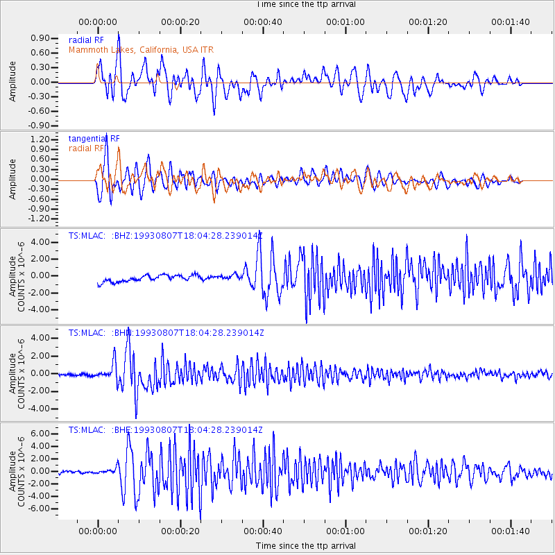
Signal To Noise
| Channel | StoN | STA | LTA |
| TS:MLAC: :BHN:19930807T18:04:28.239014Z | 10.627589 | 1.0143516E-6 | 9.544513E-8 |
| TS:MLAC: :BHE:19930807T18:04:28.239014Z | 2.007683 | 5.244421E-7 | 2.612176E-7 |
| TS:MLAC: :BHZ:19930807T18:04:28.239014Z | 0.84048414 | 3.2342857E-7 | 3.848122E-7 |
| Arrivals |
| Ps | |
| PpPs | |
| PsPs/PpSs | |


