You are here: Home > Network List > II - Global Seismograph Network (GSN - IRIS/IDA) Stations List
> Station WRAB Tennant Creek, NT, Australia > Earthquake Result Viewer
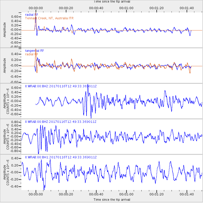
WRAB Tennant Creek, NT, Australia - Earthquake Result Viewer
*The percent match for this event was below the threshold and hence no stack was calculated.
| Earthquake location: |
Northern Sumatra, Indonesia |
| Earthquake latitude/longitude: |
3.3/98.5 |
| Earthquake time(UTC): |
2017/01/16 (016) 12:42:12 GMT |
| Earthquake Depth: |
10 km |
| Earthquake Magnitude: |
5.7 mb |
| Earthquake Catalog/Contributor: |
NEIC PDE/us |
|
| Network: |
II Global Seismograph Network (GSN - IRIS/IDA) |
| Station: |
WRAB Tennant Creek, NT, Australia |
| Lat/Lon: |
19.93 S/134.36 E |
| Elevation: |
366 m |
|
| Distance: |
42.0 deg |
| Az: |
124.712 deg |
| Baz: |
299.268 deg |
| Ray Param: |
$rayparam |
*The percent match for this event was below the threshold and hence was not used in the summary stack. |
|
| Radial Match: |
62.010323 % |
| Radial Bump: |
400 |
| Transverse Match: |
63.87738 % |
| Transverse Bump: |
400 |
| SOD ConfigId: |
1943534 |
| Insert Time: |
2017-01-30 12:43:10.467 +0000 |
| GWidth: |
2.5 |
| Max Bumps: |
400 |
| Tol: |
0.001 |
|
Signal To Noise
| Channel | StoN | STA | LTA |
| II:WRAB:00:BHZ:20170116T12:49:33.369011Z | 3.0020347 | 4.5774163E-7 | 1.5247713E-7 |
| II:WRAB:00:BH1:20170116T12:49:33.369011Z | 1.2828044 | 1.7554918E-7 | 1.3684797E-7 |
| II:WRAB:00:BH2:20170116T12:49:33.369011Z | 3.1980085 | 3.6193805E-7 | 1.1317608E-7 |
| Arrivals |
| Ps | |
| PpPs | |
| PsPs/PpSs | |


