You are here: Home > Network List > TA - USArray Transportable Network (new EarthScope stations) Stations List
> Station L13A Double Diamond Ranch, Oakley, ID, USA > Earthquake Result Viewer
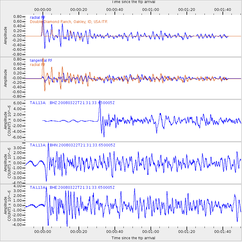
L13A Double Diamond Ranch, Oakley, ID, USA - Earthquake Result Viewer

| Earthquake location: |
Andreanof Islands, Aleutian Is. |
| Earthquake latitude/longitude: |
52.2/-178.7 |
| Earthquake time(UTC): |
2008/03/22 (082) 21:24:11 GMT |
| Earthquake Depth: |
132 km |
| Earthquake Magnitude: |
5.8 MB, 6.2 MW, 6.1 MW |
| Earthquake Catalog/Contributor: |
WHDF/NEIC |
|
| Network: |
TA USArray Transportable Network (new EarthScope stations) |
| Station: |
L13A Double Diamond Ranch, Oakley, ID, USA |
| Lat/Lon: |
42.09 N/113.94 W |
| Elevation: |
1482 m |
|
| Distance: |
43.8 deg |
| Az: |
76.531 deg |
| Baz: |
306.432 deg |
| Ray Param: |
0.071834244 |
| Estimated Moho Depth: |
42.75 km |
| Estimated Crust Vp/Vs: |
1.70 |
| Assumed Crust Vp: |
6.279 km/s |
| Estimated Crust Vs: |
3.688 km/s |
| Estimated Crust Poisson's Ratio: |
0.24 |
|
| Radial Match: |
86.49719 % |
| Radial Bump: |
400 |
| Transverse Match: |
74.50134 % |
| Transverse Bump: |
400 |
| SOD ConfigId: |
2564 |
| Insert Time: |
2010-03-07 04:13:19.413 +0000 |
| GWidth: |
2.5 |
| Max Bumps: |
400 |
| Tol: |
0.001 |
|
Signal To Noise
| Channel | StoN | STA | LTA |
| TA:L13A: :BHN:20080322T21:31:33.650005Z | 8.220994 | 1.6714472E-6 | 2.033145E-7 |
| TA:L13A: :BHE:20080322T21:31:33.650005Z | 13.297387 | 1.8195177E-6 | 1.3683272E-7 |
| TA:L13A: :BHZ:20080322T21:31:33.650005Z | 16.82213 | 2.9551554E-6 | 1.756707E-7 |
| Arrivals |
| Ps | 5.1 SECOND |
| PpPs | 17 SECOND |
| PsPs/PpSs | 22 SECOND |


