You are here: Home > Network List > TA - USArray Transportable Network (new EarthScope stations) Stations List
> Station L13A Double Diamond Ranch, Oakley, ID, USA > Earthquake Result Viewer
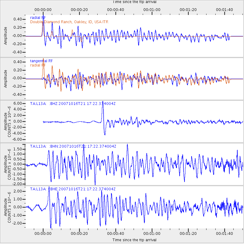
L13A Double Diamond Ranch, Oakley, ID, USA - Earthquake Result Viewer

| Earthquake location: |
South Of Fiji Islands |
| Earthquake latitude/longitude: |
-25.8/179.5 |
| Earthquake time(UTC): |
2007/10/16 (289) 21:05:43 GMT |
| Earthquake Depth: |
509 km |
| Earthquake Magnitude: |
6.2 MB, 6.6 MW, 6.5 MW |
| Earthquake Catalog/Contributor: |
WHDF/NEIC |
|
| Network: |
TA USArray Transportable Network (new EarthScope stations) |
| Station: |
L13A Double Diamond Ranch, Oakley, ID, USA |
| Lat/Lon: |
42.09 N/113.94 W |
| Elevation: |
1482 m |
|
| Distance: |
91.2 deg |
| Az: |
43.071 deg |
| Baz: |
235.814 deg |
| Ray Param: |
0.04132867 |
| Estimated Moho Depth: |
37.5 km |
| Estimated Crust Vp/Vs: |
1.84 |
| Assumed Crust Vp: |
6.279 km/s |
| Estimated Crust Vs: |
3.412 km/s |
| Estimated Crust Poisson's Ratio: |
0.29 |
|
| Radial Match: |
87.19217 % |
| Radial Bump: |
400 |
| Transverse Match: |
80.475174 % |
| Transverse Bump: |
400 |
| SOD ConfigId: |
2564 |
| Insert Time: |
2010-03-07 04:13:35.562 +0000 |
| GWidth: |
2.5 |
| Max Bumps: |
400 |
| Tol: |
0.001 |
|
Signal To Noise
| Channel | StoN | STA | LTA |
| TA:L13A: :BHN:20071016T21:17:22.374004Z | 7.4417715 | 7.0619797E-7 | 9.4896485E-8 |
| TA:L13A: :BHE:20071016T21:17:22.374004Z | 7.8599257 | 1.1707252E-6 | 1.4894863E-7 |
| TA:L13A: :BHZ:20071016T21:17:22.374004Z | 24.774267 | 2.6915743E-6 | 1.0864396E-7 |
| Arrivals |
| Ps | 5.1 SECOND |
| PpPs | 17 SECOND |
| PsPs/PpSs | 22 SECOND |


