You are here: Home > Network List > TA - USArray Transportable Network (new EarthScope stations) Stations List
> Station L13A Double Diamond Ranch, Oakley, ID, USA > Earthquake Result Viewer
L13A Double Diamond Ranch, Oakley, ID, USA - Earthquake Result Viewer

| Earthquake location: |
Vanuatu Islands |
| Earthquake latitude/longitude: |
-15.6/167.7 |
| Earthquake time(UTC): |
2007/08/01 (213) 17:08:51 GMT |
| Earthquake Depth: |
120 km |
| Earthquake Magnitude: |
6.2 MB, 7.2 MW, 7.2 MW |
| Earthquake Catalog/Contributor: |
WHDF/NEIC |
|
| Network: |
TA USArray Transportable Network (new EarthScope stations) |
| Station: |
L13A Double Diamond Ranch, Oakley, ID, USA |
| Lat/Lon: |
42.09 N/113.94 W |
| Elevation: |
1482 m |
|
| Distance: |
91.9 deg |
| Az: |
46.844 deg |
| Baz: |
250.809 deg |
| Ray Param: |
0.04148212 |
| Estimated Moho Depth: |
37.5 km |
| Estimated Crust Vp/Vs: |
1.83 |
| Assumed Crust Vp: |
6.279 km/s |
| Estimated Crust Vs: |
3.44 km/s |
| Estimated Crust Poisson's Ratio: |
0.29 |
|
| Radial Match: |
93.981705 % |
| Radial Bump: |
400 |
| Transverse Match: |
84.71383 % |
| Transverse Bump: |
400 |
| SOD ConfigId: |
2564 |
| Insert Time: |
2010-03-07 04:14:01.276 +0000 |
| GWidth: |
2.5 |
| Max Bumps: |
400 |
| Tol: |
0.001 |
|
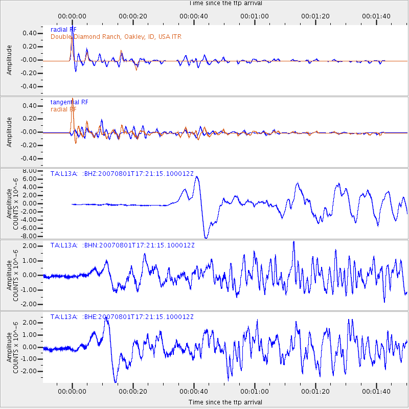
Signal To Noise
| Channel | StoN | STA | LTA |
| TA:L13A: :BHN:20070801T17:21:15.100012Z | 1.0719855 | 7.099258E-8 | 6.622531E-8 |
| TA:L13A: :BHE:20070801T17:21:15.100012Z | 1.7263882 | 1.7395533E-7 | 1.0076258E-7 |
| TA:L13A: :BHZ:20070801T17:21:15.100012Z | 4.0083733 | 3.9533643E-7 | 9.862765E-8 |
| Arrivals |
| Ps | 5.0 SECOND |
| PpPs | 17 SECOND |
| PsPs/PpSs | 22 SECOND |


