You are here: Home > Network List > TA - USArray Transportable Network (new EarthScope stations) Stations List
> Station L13A Double Diamond Ranch, Oakley, ID, USA > Earthquake Result Viewer
L13A Double Diamond Ranch, Oakley, ID, USA - Earthquake Result Viewer

| Earthquake location: |
Sea Of Japan |
| Earthquake latitude/longitude: |
36.8/134.9 |
| Earthquake time(UTC): |
2007/07/16 (197) 14:17:37 GMT |
| Earthquake Depth: |
350 km |
| Earthquake Magnitude: |
6.2 MB, 6.8 MW, 6.8 MW |
| Earthquake Catalog/Contributor: |
WHDF/NEIC |
|
| Network: |
TA USArray Transportable Network (new EarthScope stations) |
| Station: |
L13A Double Diamond Ranch, Oakley, ID, USA |
| Lat/Lon: |
42.09 N/113.94 W |
| Elevation: |
1482 m |
|
| Distance: |
79.5 deg |
| Az: |
44.892 deg |
| Baz: |
310.449 deg |
| Ray Param: |
0.047970314 |
| Estimated Moho Depth: |
29.0 km |
| Estimated Crust Vp/Vs: |
2.05 |
| Assumed Crust Vp: |
6.279 km/s |
| Estimated Crust Vs: |
3.07 km/s |
| Estimated Crust Poisson's Ratio: |
0.34 |
|
| Radial Match: |
87.79536 % |
| Radial Bump: |
400 |
| Transverse Match: |
69.96981 % |
| Transverse Bump: |
400 |
| SOD ConfigId: |
2564 |
| Insert Time: |
2010-03-07 04:14:07.116 +0000 |
| GWidth: |
2.5 |
| Max Bumps: |
400 |
| Tol: |
0.001 |
|
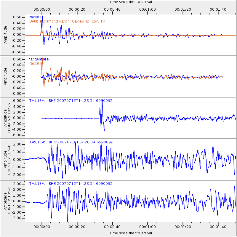
Signal To Noise
| Channel | StoN | STA | LTA |
| TA:L13A: :BHN:20070716T14:28:34.699009Z | 6.1158295 | 6.137638E-7 | 1.00356594E-7 |
| TA:L13A: :BHE:20070716T14:28:34.699009Z | 14.905923 | 9.003788E-7 | 6.04041E-8 |
| TA:L13A: :BHZ:20070716T14:28:34.699009Z | 36.930443 | 2.1000678E-6 | 5.686549E-8 |
| Arrivals |
| Ps | 4.9 SECOND |
| PpPs | 14 SECOND |
| PsPs/PpSs | 19 SECOND |


