You are here: Home > Network List > TA - USArray Transportable Network (new EarthScope stations) Stations List
> Station L13A Double Diamond Ranch, Oakley, ID, USA > Earthquake Result Viewer
L13A Double Diamond Ranch, Oakley, ID, USA - Earthquake Result Viewer
| Earthquake location: |
Near Coast Of Peru |
| Earthquake latitude/longitude: |
-15.7/-74.9 |
| Earthquake time(UTC): |
2007/06/28 (179) 08:44:48 GMT |
| Earthquake Depth: |
27 km |
| Earthquake Magnitude: |
5.5 MB, 5.3 MS, 5.8 MW, 5.8 MW |
| Earthquake Catalog/Contributor: |
WHDF/NEIC |
|
| Network: |
TA USArray Transportable Network (new EarthScope stations) |
| Station: |
L13A Double Diamond Ranch, Oakley, ID, USA |
| Lat/Lon: |
42.09 N/113.94 W |
| Elevation: |
1482 m |
|
| Distance: |
67.8 deg |
| Az: |
329.575 deg |
| Baz: |
139.055 deg |
| Ray Param: |
0.056662746 |
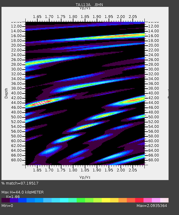
| Estimated Moho Depth: |
44.0 km |
| Estimated Crust Vp/Vs: |
1.66 |
| Assumed Crust Vp: |
6.279 km/s |
| Estimated Crust Vs: |
3.782 km/s |
| Estimated Crust Poisson's Ratio: |
0.22 |
|
| Radial Match: |
87.19517 % |
| Radial Bump: |
400 |
| Transverse Match: |
84.73959 % |
| Transverse Bump: |
400 |
| SOD ConfigId: |
2564 |
| Insert Time: |
2010-03-07 04:14:24.108 +0000 |
| GWidth: |
2.5 |
| Max Bumps: |
400 |
| Tol: |
0.001 |
|

Signal To Noise
| Channel | StoN | STA | LTA |
| TA:L13A: :BHN:20070628T08:55:13.173018Z | 2.378464 | 1.0536478E-7 | 4.4299508E-8 |
| TA:L13A: :BHE:20070628T08:55:13.173018Z | 4.0136275 | 1.4320203E-7 | 3.5678955E-8 |
| TA:L13A: :BHZ:20070628T08:55:13.173018Z | 4.9648147 | 2.6569725E-7 | 5.3516047E-8 |
| Arrivals |
| Ps | 4.8 SECOND |
| PpPs | 18 SECOND |
| PsPs/PpSs | 23 SECOND |


