You are here: Home > Network List > GT - Global Telemetered Seismograph Network (USAF/USGS) Stations List
> Station LPAZ La Paz , Bolivia > Earthquake Result Viewer
LPAZ La Paz , Bolivia - Earthquake Result Viewer
| Earthquake location: |
Cuba Region |
| Earthquake latitude/longitude: |
19.9/-76.6 |
| Earthquake time(UTC): |
2017/01/17 (017) 09:08:01 GMT |
| Earthquake Depth: |
10 km |
| Earthquake Magnitude: |
5.8 Mww |
| Earthquake Catalog/Contributor: |
NEIC PDE/us |
|
| Network: |
GT Global Telemetered Seismograph Network (USAF/USGS) |
| Station: |
LPAZ La Paz , Bolivia |
| Lat/Lon: |
16.17 S/68.08 W |
| Elevation: |
4817 m |
|
| Distance: |
36.8 deg |
| Az: |
166.233 deg |
| Baz: |
346.52 deg |
| Ray Param: |
0.07649345 |
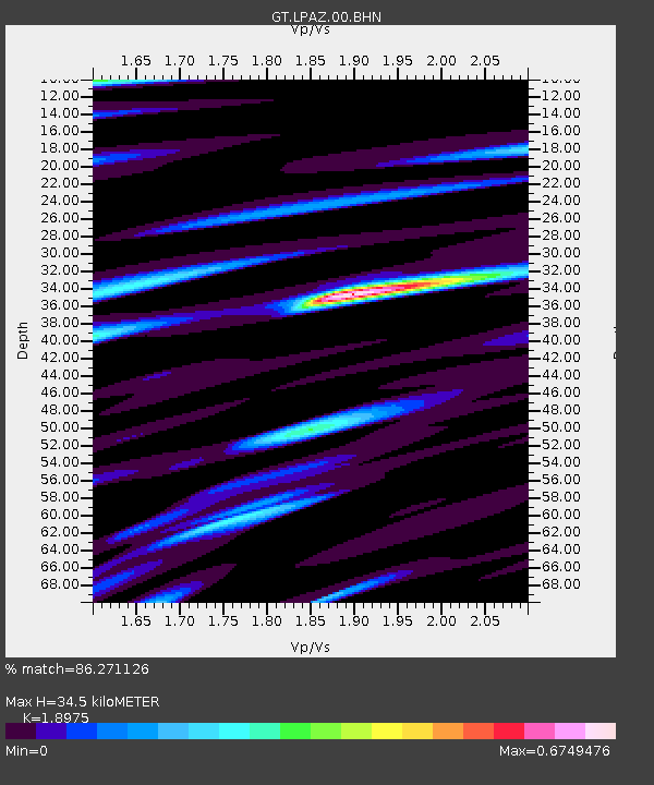
| Estimated Moho Depth: |
34.5 km |
| Estimated Crust Vp/Vs: |
1.90 |
| Assumed Crust Vp: |
6.454 km/s |
| Estimated Crust Vs: |
3.401 km/s |
| Estimated Crust Poisson's Ratio: |
0.31 |
|
| Radial Match: |
86.271126 % |
| Radial Bump: |
357 |
| Transverse Match: |
69.01388 % |
| Transverse Bump: |
400 |
| SOD ConfigId: |
1943534 |
| Insert Time: |
2017-01-31 09:12:49.968 +0000 |
| GWidth: |
2.5 |
| Max Bumps: |
400 |
| Tol: |
0.001 |
|

Signal To Noise
| Channel | StoN | STA | LTA |
| GT:LPAZ:00:BHZ:20170117T09:14:39.724994Z | 2.1694956 | 1.7425867E-7 | 8.032221E-8 |
| GT:LPAZ:00:BHN:20170117T09:14:39.724994Z | 2.0413246 | 9.8953116E-8 | 4.8474952E-8 |
| GT:LPAZ:00:BHE:20170117T09:14:39.724994Z | 0.42878893 | 3.6916703E-8 | 8.6095284E-8 |
| Arrivals |
| Ps | 5.1 SECOND |
| PpPs | 14 SECOND |
| PsPs/PpSs | 20 SECOND |


