You are here: Home > Network List > TA - USArray Transportable Network (new EarthScope stations) Stations List
> Station O13A Hicks Ranch, Ibapah, UT, USA > Earthquake Result Viewer
O13A Hicks Ranch, Ibapah, UT, USA - Earthquake Result Viewer
| Earthquake location: |
South Of Fiji Islands |
| Earthquake latitude/longitude: |
-25.8/179.5 |
| Earthquake time(UTC): |
2007/10/16 (289) 21:05:43 GMT |
| Earthquake Depth: |
509 km |
| Earthquake Magnitude: |
6.2 MB, 6.6 MW, 6.5 MW |
| Earthquake Catalog/Contributor: |
WHDF/NEIC |
|
| Network: |
TA USArray Transportable Network (new EarthScope stations) |
| Station: |
O13A Hicks Ranch, Ibapah, UT, USA |
| Lat/Lon: |
40.13 N/113.98 W |
| Elevation: |
1573 m |
|
| Distance: |
90.1 deg |
| Az: |
44.672 deg |
| Baz: |
235.771 deg |
| Ray Param: |
0.041527234 |
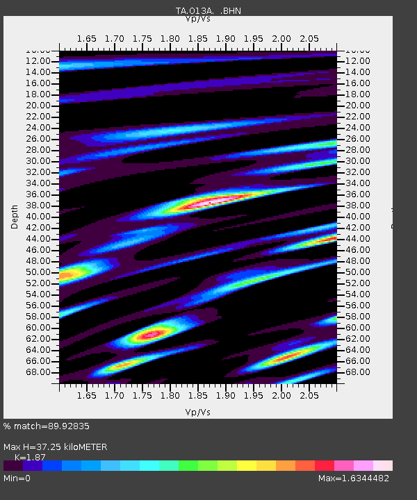
| Estimated Moho Depth: |
37.25 km |
| Estimated Crust Vp/Vs: |
1.87 |
| Assumed Crust Vp: |
6.276 km/s |
| Estimated Crust Vs: |
3.356 km/s |
| Estimated Crust Poisson's Ratio: |
0.30 |
|
| Radial Match: |
89.92835 % |
| Radial Bump: |
400 |
| Transverse Match: |
85.423355 % |
| Transverse Bump: |
400 |
| SOD ConfigId: |
2564 |
| Insert Time: |
2010-03-07 04:16:38.510 +0000 |
| GWidth: |
2.5 |
| Max Bumps: |
400 |
| Tol: |
0.001 |
|

Signal To Noise
| Channel | StoN | STA | LTA |
| TA:O13A: :BHN:20071016T21:17:17.199016Z | 9.407496 | 1.6460688E-6 | 1.7497416E-7 |
| TA:O13A: :BHE:20071016T21:17:17.199016Z | 14.145656 | 1.9465804E-6 | 1.3760976E-7 |
| TA:O13A: :BHZ:20071016T21:17:17.199016Z | 35.908005 | 3.8968737E-6 | 1.0852382E-7 |
| Arrivals |
| Ps | 5.3 SECOND |
| PpPs | 17 SECOND |
| PsPs/PpSs | 22 SECOND |


