You are here: Home > Network List > TA - USArray Transportable Network (new EarthScope stations) Stations List
> Station O13A Hicks Ranch, Ibapah, UT, USA > Earthquake Result Viewer
O13A Hicks Ranch, Ibapah, UT, USA - Earthquake Result Viewer
| Earthquake location: |
Kuril Islands |
| Earthquake latitude/longitude: |
49.7/154.3 |
| Earthquake time(UTC): |
2007/08/28 (240) 01:16:04 GMT |
| Earthquake Depth: |
116 km |
| Earthquake Magnitude: |
5.5 MB, 5.6 MW |
| Earthquake Catalog/Contributor: |
WHDF/NEIC |
|
| Network: |
TA USArray Transportable Network (new EarthScope stations) |
| Station: |
O13A Hicks Ranch, Ibapah, UT, USA |
| Lat/Lon: |
40.13 N/113.98 W |
| Elevation: |
1573 m |
|
| Distance: |
61.8 deg |
| Az: |
60.446 deg |
| Baz: |
312.535 deg |
| Ray Param: |
0.06034051 |
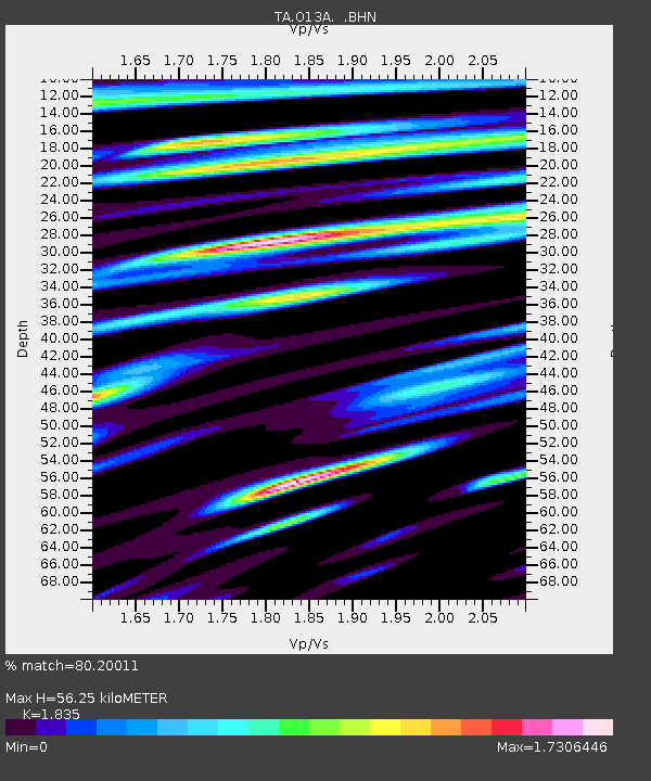
| Estimated Moho Depth: |
56.25 km |
| Estimated Crust Vp/Vs: |
1.84 |
| Assumed Crust Vp: |
6.276 km/s |
| Estimated Crust Vs: |
3.42 km/s |
| Estimated Crust Poisson's Ratio: |
0.29 |
|
| Radial Match: |
80.20011 % |
| Radial Bump: |
400 |
| Transverse Match: |
75.40713 % |
| Transverse Bump: |
400 |
| SOD ConfigId: |
2564 |
| Insert Time: |
2010-03-07 04:16:41.408 +0000 |
| GWidth: |
2.5 |
| Max Bumps: |
400 |
| Tol: |
0.001 |
|

Signal To Noise
| Channel | StoN | STA | LTA |
| TA:O13A: :BHN:20070828T01:25:40.173018Z | 2.4579575 | 1.3733585E-7 | 5.587397E-8 |
| TA:O13A: :BHE:20070828T01:25:40.173018Z | 1.2802684 | 1.3563836E-7 | 1.05945254E-7 |
| TA:O13A: :BHZ:20070828T01:25:40.173018Z | 2.6781402 | 2.4074455E-7 | 8.989244E-8 |
| Arrivals |
| Ps | 7.8 SECOND |
| PpPs | 24 SECOND |
| PsPs/PpSs | 32 SECOND |


