You are here: Home > Network List > TA - USArray Transportable Network (new EarthScope stations) Stations List
> Station O13A Hicks Ranch, Ibapah, UT, USA > Earthquake Result Viewer
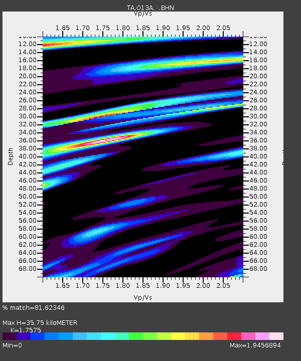
O13A Hicks Ranch, Ibapah, UT, USA - Earthquake Result Viewer
| Earthquake location: |
Andreanof Islands, Aleutian Is. |
| Earthquake latitude/longitude: |
50.3/-177.5 |
| Earthquake time(UTC): |
2007/08/15 (227) 20:22:11 GMT |
| Earthquake Depth: |
9.0 km |
| Earthquake Magnitude: |
6.3 MB, 6.2 MS, 6.4 MW, 5.9 ML |
| Earthquake Catalog/Contributor: |
WHDF/NEIC |
|
| Network: |
TA USArray Transportable Network (new EarthScope stations) |
| Station: |
O13A Hicks Ranch, Ibapah, UT, USA |
| Lat/Lon: |
40.13 N/113.98 W |
| Elevation: |
1573 m |
|
| Distance: |
44.6 deg |
| Az: |
77.709 deg |
| Baz: |
305.224 deg |
| Ray Param: |
0.071794994 |
| Estimated Moho Depth: |
35.75 km |
| Estimated Crust Vp/Vs: |
1.76 |
| Assumed Crust Vp: |
6.276 km/s |
| Estimated Crust Vs: |
3.571 km/s |
| Estimated Crust Poisson's Ratio: |
0.26 |
|
| Radial Match: |
81.62346 % |
| Radial Bump: |
400 |
| Transverse Match: |
66.102516 % |
| Transverse Bump: |
400 |
| SOD ConfigId: |
2564 |
| Insert Time: |
2010-03-07 04:16:46.827 +0000 |
| GWidth: |
2.5 |
| Max Bumps: |
400 |
| Tol: |
0.001 |
|

Signal To Noise
| Channel | StoN | STA | LTA |
| TA:O13A: :BHN:20070815T20:29:52.975011Z | 3.8728666 | 6.7256894E-7 | 1.7366179E-7 |
| TA:O13A: :BHE:20070815T20:29:52.975011Z | 3.820217 | 1.8759898E-6 | 4.9106893E-7 |
| TA:O13A: :BHZ:20070815T20:29:52.975011Z | 10.155288 | 2.5285547E-6 | 2.4898898E-7 |
| Arrivals |
| Ps | 4.6 SECOND |
| PpPs | 15 SECOND |
| PsPs/PpSs | 19 SECOND |


