You are here: Home > Network List > TA - USArray Transportable Network (new EarthScope stations) Stations List
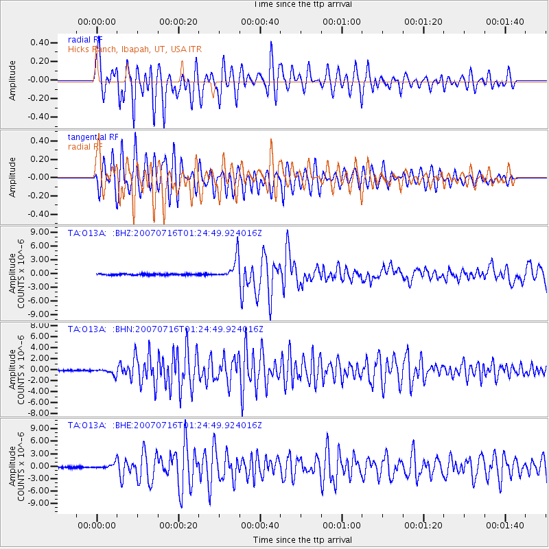
> Station O13A Hicks Ranch, Ibapah, UT, USA > Earthquake Result Viewer
O13A Hicks Ranch, Ibapah, UT, USA - Earthquake Result Viewer
| Earthquake location: |
Near West Coast Of Honshu, Japan |
| Earthquake latitude/longitude: |
37.5/138.4 |
| Earthquake time(UTC): |
2007/07/16 (197) 01:13:22 GMT |
| Earthquake Depth: |
12 km |
| Earthquake Magnitude: |
6.5 MB, 6.4 MS, 6.6 MW, 6.5 MW |
| Earthquake Catalog/Contributor: |
WHDF/NEIC |
|
| Network: |
TA USArray Transportable Network (new EarthScope stations) |
| Station: |
O13A Hicks Ranch, Ibapah, UT, USA |
| Lat/Lon: |
40.13 N/113.98 W |
| Elevation: |
1573 m |
|
| Distance: |
78.1 deg |
| Az: |
48.319 deg |
| Baz: |
309.251 deg |
| Ray Param: |
0.049839012 |
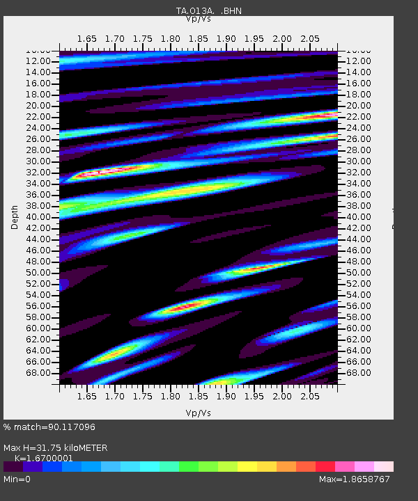
| Estimated Moho Depth: |
31.75 km |
| Estimated Crust Vp/Vs: |
1.67 |
| Assumed Crust Vp: |
6.276 km/s |
| Estimated Crust Vs: |
3.758 km/s |
| Estimated Crust Poisson's Ratio: |
0.22 |
|
| Radial Match: |
90.117096 % |
| Radial Bump: |
400 |
| Transverse Match: |
88.40666 % |
| Transverse Bump: |
400 |
| SOD ConfigId: |
2564 |
| Insert Time: |
2010-03-07 04:16:59.443 +0000 |
| GWidth: |
2.5 |
| Max Bumps: |
400 |
| Tol: |
0.001 |
|
Signal To Noise
| Channel | StoN | STA | LTA |
| TA:O13A: :BHN:20070716T01:24:49.924016Z | 6.547674 | 5.7018707E-7 | 8.7082384E-8 |
| TA:O13A: :BHE:20070716T01:24:49.924016Z | 5.1232285 | 7.005283E-7 | 1.3673571E-7 |
| TA:O13A: :BHZ:20070716T01:24:49.924016Z | 18.22966 | 2.5162951E-6 | 1.3803303E-7 |
| Arrivals |
| Ps | 3.5 SECOND |
| PpPs | 13 SECOND |
| PsPs/PpSs | 17 SECOND |


