You are here: Home > Network List > TA - USArray Transportable Network (new EarthScope stations) Stations List
> Station O13A Hicks Ranch, Ibapah, UT, USA > Earthquake Result Viewer
O13A Hicks Ranch, Ibapah, UT, USA - Earthquake Result Viewer
| Earthquake location: |
Fox Islands, Aleutian Islands |
| Earthquake latitude/longitude: |
52.5/-168.0 |
| Earthquake time(UTC): |
2007/07/15 (196) 13:08:00 GMT |
| Earthquake Depth: |
10 km |
| Earthquake Magnitude: |
5.8 MB, 5.9 MS, 6.1 MW, 6.0 MW |
| Earthquake Catalog/Contributor: |
WHDF/NEIC |
|
| Network: |
TA USArray Transportable Network (new EarthScope stations) |
| Station: |
O13A Hicks Ranch, Ibapah, UT, USA |
| Lat/Lon: |
40.13 N/113.98 W |
| Elevation: |
1573 m |
|
| Distance: |
38.5 deg |
| Az: |
86.617 deg |
| Baz: |
307.217 deg |
| Ray Param: |
0.07555332 |
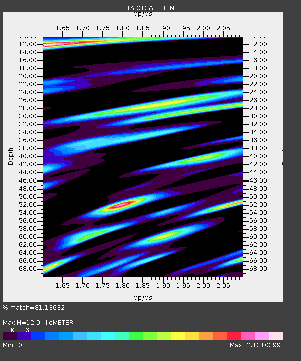
| Estimated Moho Depth: |
12.0 km |
| Estimated Crust Vp/Vs: |
1.60 |
| Assumed Crust Vp: |
6.276 km/s |
| Estimated Crust Vs: |
3.922 km/s |
| Estimated Crust Poisson's Ratio: |
0.18 |
|
| Radial Match: |
81.13632 % |
| Radial Bump: |
400 |
| Transverse Match: |
84.29341 % |
| Transverse Bump: |
400 |
| SOD ConfigId: |
2564 |
| Insert Time: |
2010-03-07 04:17:00.918 +0000 |
| GWidth: |
2.5 |
| Max Bumps: |
400 |
| Tol: |
0.001 |
|

Signal To Noise
| Channel | StoN | STA | LTA |
| TA:O13A: :BHN:20070715T13:14:51.875002Z | 1.5570924 | 9.871825E-8 | 6.33991E-8 |
| TA:O13A: :BHE:20070715T13:14:51.875002Z | 2.7913768 | 2.3540473E-7 | 8.433284E-8 |
| TA:O13A: :BHZ:20070715T13:14:51.875002Z | 4.861314 | 3.3569393E-7 | 6.905415E-8 |
| Arrivals |
| Ps | 1.2 SECOND |
| PpPs | 4.6 SECOND |
| PsPs/PpSs | 5.8 SECOND |


