You are here: Home > Network List > TA - USArray Transportable Network (new EarthScope stations) Stations List
> Station O13A Hicks Ranch, Ibapah, UT, USA > Earthquake Result Viewer
O13A Hicks Ranch, Ibapah, UT, USA - Earthquake Result Viewer
| Earthquake location: |
Solomon Islands |
| Earthquake latitude/longitude: |
-8.5/156.7 |
| Earthquake time(UTC): |
2007/04/01 (091) 21:18:22 GMT |
| Earthquake Depth: |
10 km |
| Earthquake Magnitude: |
5.8 MB |
| Earthquake Catalog/Contributor: |
WHDF/NEIC |
|
| Network: |
TA USArray Transportable Network (new EarthScope stations) |
| Station: |
O13A Hicks Ranch, Ibapah, UT, USA |
| Lat/Lon: |
40.13 N/113.98 W |
| Elevation: |
1573 m |
|
| Distance: |
94.9 deg |
| Az: |
50.302 deg |
| Baz: |
263.034 deg |
| Ray Param: |
0.040931463 |
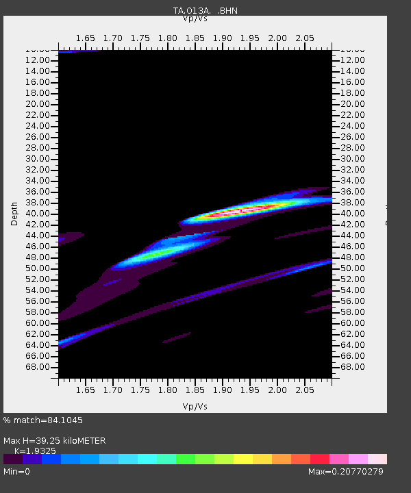
| Estimated Moho Depth: |
39.25 km |
| Estimated Crust Vp/Vs: |
1.93 |
| Assumed Crust Vp: |
6.276 km/s |
| Estimated Crust Vs: |
3.248 km/s |
| Estimated Crust Poisson's Ratio: |
0.32 |
|
| Radial Match: |
84.1045 % |
| Radial Bump: |
400 |
| Transverse Match: |
45.927467 % |
| Transverse Bump: |
315 |
| SOD ConfigId: |
2564 |
| Insert Time: |
2010-03-07 04:17:10.142 +0000 |
| GWidth: |
2.5 |
| Max Bumps: |
400 |
| Tol: |
0.001 |
|
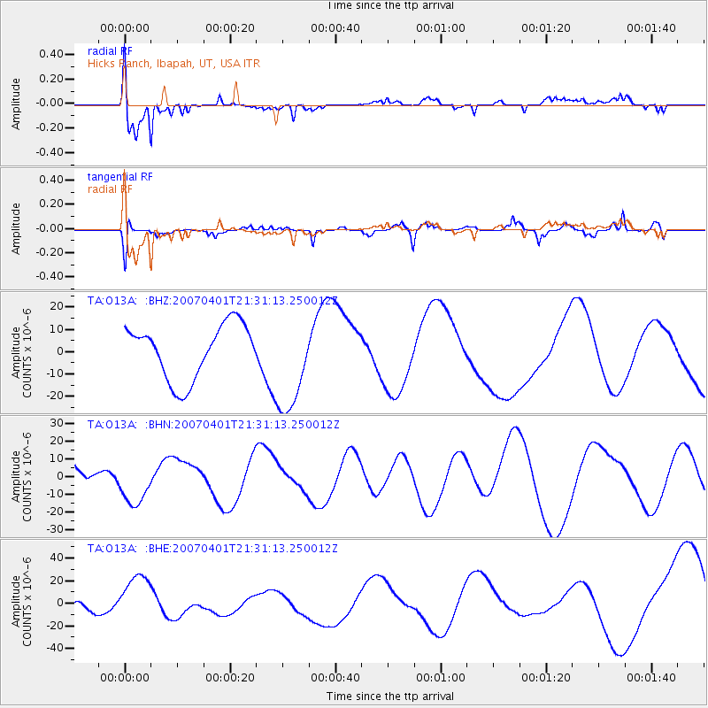
Signal To Noise
| Channel | StoN | STA | LTA |
| TA:O13A: :BHN:20070401T21:31:13.250012Z | 1.3282709 | 1.3633434E-5 | 1.0264046E-5 |
| TA:O13A: :BHE:20070401T21:31:13.250012Z | 6.9596934 | 2.378733E-5 | 3.4178704E-6 |
| TA:O13A: :BHZ:20070401T21:31:13.250012Z | 1.8210473 | 2.201226E-5 | 1.2087693E-5 |
| Arrivals |
| Ps | 5.9 SECOND |
| PpPs | 18 SECOND |
| PsPs/PpSs | 24 SECOND |


