You are here: Home > Network List > TA - USArray Transportable Network (new EarthScope stations) Stations List
> Station H10A Noah's Angus Ranch, Cambridge, ID, USA > Earthquake Result Viewer
H10A Noah's Angus Ranch, Cambridge, ID, USA - Earthquake Result Viewer
| Earthquake location: |
Windward Islands |
| Earthquake latitude/longitude: |
15.0/-61.3 |
| Earthquake time(UTC): |
2007/11/29 (333) 19:00:19 GMT |
| Earthquake Depth: |
148 km |
| Earthquake Magnitude: |
6.9 MB, 7.4 MW, 7.4 MW |
| Earthquake Catalog/Contributor: |
WHDF/NEIC |
|
| Network: |
TA USArray Transportable Network (new EarthScope stations) |
| Station: |
H10A Noah's Angus Ranch, Cambridge, ID, USA |
| Lat/Lon: |
44.59 N/116.75 W |
| Elevation: |
882 m |
|
| Distance: |
55.2 deg |
| Az: |
314.185 deg |
| Baz: |
104.077 deg |
| Ray Param: |
0.06447839 |
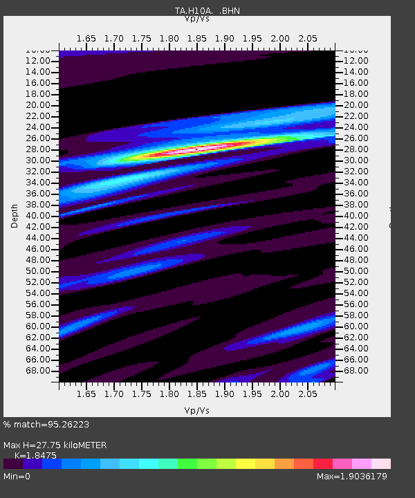
| Estimated Moho Depth: |
27.75 km |
| Estimated Crust Vp/Vs: |
1.85 |
| Assumed Crust Vp: |
6.571 km/s |
| Estimated Crust Vs: |
3.557 km/s |
| Estimated Crust Poisson's Ratio: |
0.29 |
|
| Radial Match: |
95.26223 % |
| Radial Bump: |
379 |
| Transverse Match: |
80.62594 % |
| Transverse Bump: |
400 |
| SOD ConfigId: |
2564 |
| Insert Time: |
2010-03-07 04:17:24.484 +0000 |
| GWidth: |
2.5 |
| Max Bumps: |
400 |
| Tol: |
0.001 |
|
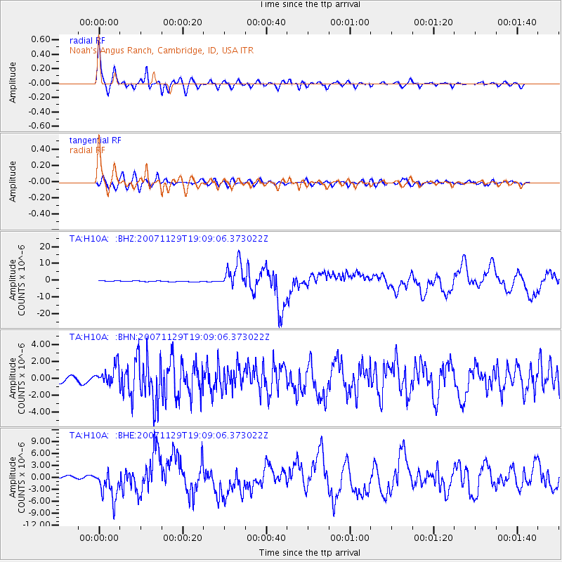
Signal To Noise
| Channel | StoN | STA | LTA |
| TA:H10A: :BHN:20071129T19:09:06.373022Z | 4.422771 | 1.1488437E-6 | 2.5975655E-7 |
| TA:H10A: :BHE:20071129T19:09:06.373022Z | 15.977426 | 3.8173616E-6 | 2.3892218E-7 |
| TA:H10A: :BHZ:20071129T19:09:06.373022Z | 36.104877 | 7.718418E-6 | 2.137777E-7 |
| Arrivals |
| Ps | 3.8 SECOND |
| PpPs | 11 SECOND |
| PsPs/PpSs | 15 SECOND |


