You are here: Home > Network List > TA - USArray Transportable Network (new EarthScope stations) Stations List
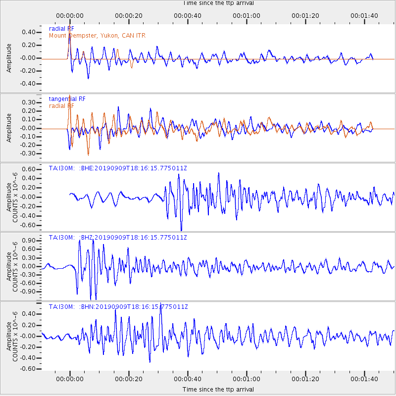
> Station I30M Mount Dempster, Yukon, CAN > Earthquake Result Viewer
I30M Mount Dempster, Yukon, CAN - Earthquake Result Viewer
| Earthquake location: |
Near Coast Of Venezuela |
| Earthquake latitude/longitude: |
10.5/-64.4 |
| Earthquake time(UTC): |
2019/09/09 (252) 18:05:17 GMT |
| Earthquake Depth: |
10 km |
| Earthquake Magnitude: |
5.5 Mww |
| Earthquake Catalog/Contributor: |
NEIC PDE/us |
|
| Network: |
TA USArray Transportable Network (new EarthScope stations) |
| Station: |
I30M Mount Dempster, Yukon, CAN |
| Lat/Lon: |
65.22 N/136.38 W |
| Elevation: |
1399 m |
|
| Distance: |
73.0 deg |
| Az: |
335.232 deg |
| Baz: |
102.098 deg |
| Ray Param: |
0.053287953 |
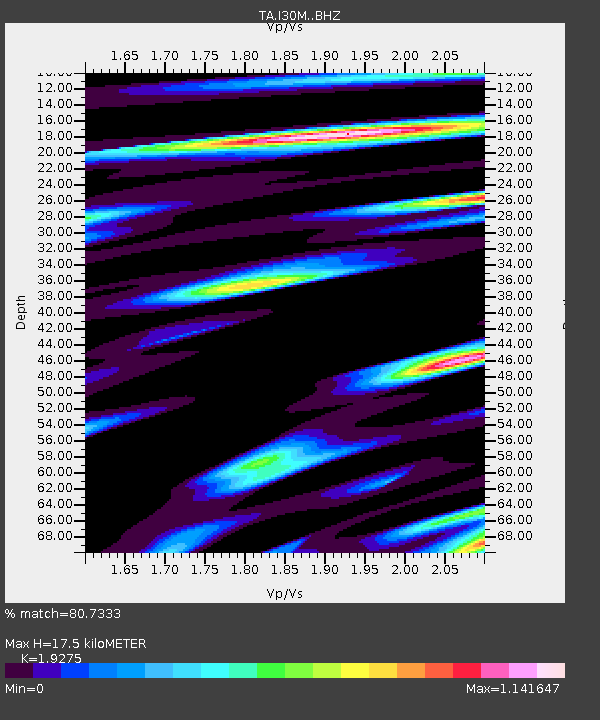
| Estimated Moho Depth: |
17.5 km |
| Estimated Crust Vp/Vs: |
1.93 |
| Assumed Crust Vp: |
6.566 km/s |
| Estimated Crust Vs: |
3.407 km/s |
| Estimated Crust Poisson's Ratio: |
0.32 |
|
| Radial Match: |
80.7333 % |
| Radial Bump: |
400 |
| Transverse Match: |
75.10934 % |
| Transverse Bump: |
400 |
| SOD ConfigId: |
19053131 |
| Insert Time: |
2019-09-23 18:15:06.559 +0000 |
| GWidth: |
2.5 |
| Max Bumps: |
400 |
| Tol: |
0.001 |
|
Signal To Noise
| Channel | StoN | STA | LTA |
| TA:I30M: :BHZ:20190909T18:16:15.775011Z | 4.1564927 | 3.9761667E-7 | 9.566159E-8 |
| TA:I30M: :BHN:20190909T18:16:15.775011Z | 0.9732075 | 6.04826E-8 | 6.214769E-8 |
| TA:I30M: :BHE:20190909T18:16:15.775011Z | 2.325511 | 1.7244608E-7 | 7.4154066E-8 |
| Arrivals |
| Ps | 2.6 SECOND |
| PpPs | 7.5 SECOND |
| PsPs/PpSs | 10 SECOND |


