You are here: Home > Network List > TA - USArray Transportable Network (new EarthScope stations) Stations List
> Station H10A Noah's Angus Ranch, Cambridge, ID, USA > Earthquake Result Viewer
H10A Noah's Angus Ranch, Cambridge, ID, USA - Earthquake Result Viewer
| Earthquake location: |
Santa Cruz Islands |
| Earthquake latitude/longitude: |
-11.4/166.3 |
| Earthquake time(UTC): |
2007/08/12 (224) 12:05:19 GMT |
| Earthquake Depth: |
42 km |
| Earthquake Magnitude: |
5.8 MB, 5.7 MS, 6.0 MW, 6.0 MW |
| Earthquake Catalog/Contributor: |
WHDF/NEIC |
|
| Network: |
TA USArray Transportable Network (new EarthScope stations) |
| Station: |
H10A Noah's Angus Ranch, Cambridge, ID, USA |
| Lat/Lon: |
44.59 N/116.75 W |
| Elevation: |
882 m |
|
| Distance: |
88.8 deg |
| Az: |
44.13 deg |
| Baz: |
252.862 deg |
| Ray Param: |
0.042244237 |
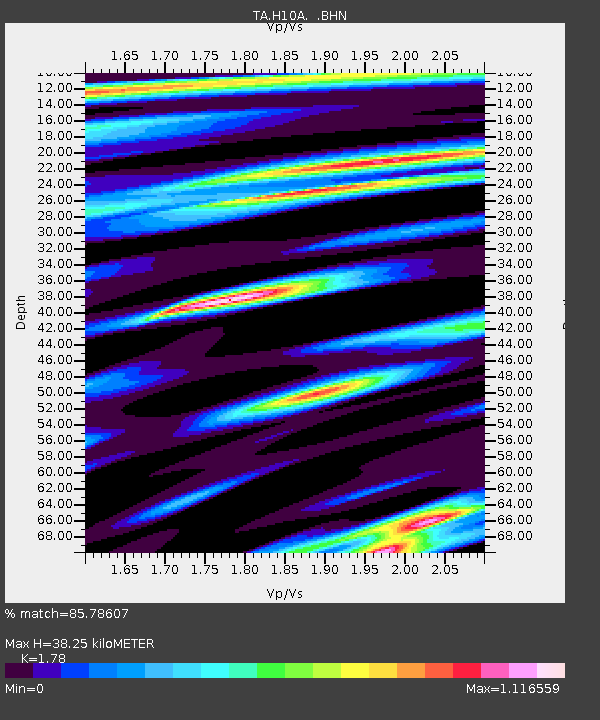
| Estimated Moho Depth: |
38.25 km |
| Estimated Crust Vp/Vs: |
1.78 |
| Assumed Crust Vp: |
6.571 km/s |
| Estimated Crust Vs: |
3.691 km/s |
| Estimated Crust Poisson's Ratio: |
0.27 |
|
| Radial Match: |
85.78607 % |
| Radial Bump: |
390 |
| Transverse Match: |
60.983837 % |
| Transverse Bump: |
400 |
| SOD ConfigId: |
2564 |
| Insert Time: |
2010-03-07 04:17:53.167 +0000 |
| GWidth: |
2.5 |
| Max Bumps: |
400 |
| Tol: |
0.001 |
|

Signal To Noise
| Channel | StoN | STA | LTA |
| TA:H10A: :BHN:20070812T12:17:38.125024Z | 0.42363957 | 5.2788163E-8 | 1.246063E-7 |
| TA:H10A: :BHE:20070812T12:17:38.125024Z | 0.89030963 | 1.071614E-7 | 1.2036419E-7 |
| TA:H10A: :BHZ:20070812T12:17:38.125024Z | 3.66441 | 4.896468E-7 | 1.3362228E-7 |
| Arrivals |
| Ps | 4.6 SECOND |
| PpPs | 16 SECOND |
| PsPs/PpSs | 20 SECOND |


