You are here: Home > Network List > IU - Global Seismograph Network (GSN - IRIS/USGS) Stations List
> Station FURI Mt. Furi, Ethiopia > Earthquake Result Viewer
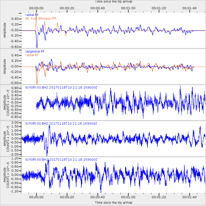
FURI Mt. Furi, Ethiopia - Earthquake Result Viewer
*The percent match for this event was below the threshold and hence no stack was calculated.
| Earthquake location: |
Central Italy |
| Earthquake latitude/longitude: |
42.6/13.2 |
| Earthquake time(UTC): |
2017/01/18 (018) 10:14:11 GMT |
| Earthquake Depth: |
10 km |
| Earthquake Magnitude: |
5.7 mb |
| Earthquake Catalog/Contributor: |
NEIC PDE/us |
|
| Network: |
IU Global Seismograph Network (GSN - IRIS/USGS) |
| Station: |
FURI Mt. Furi, Ethiopia |
| Lat/Lon: |
8.90 N/38.68 E |
| Elevation: |
2570 m |
|
| Distance: |
40.3 deg |
| Az: |
139.006 deg |
| Baz: |
330.649 deg |
| Ray Param: |
$rayparam |
*The percent match for this event was below the threshold and hence was not used in the summary stack. |
|
| Radial Match: |
77.26783 % |
| Radial Bump: |
400 |
| Transverse Match: |
64.582375 % |
| Transverse Bump: |
400 |
| SOD ConfigId: |
1943534 |
| Insert Time: |
2017-02-01 10:17:05.875 +0000 |
| GWidth: |
2.5 |
| Max Bumps: |
400 |
| Tol: |
0.001 |
|
Signal To Noise
| Channel | StoN | STA | LTA |
| IU:FURI:00:BHZ:20170118T10:21:18.169009Z | 1.2977898 | 3.472503E-7 | 2.6757056E-7 |
| IU:FURI:00:BH1:20170118T10:21:18.169009Z | 1.0170567 | 2.3383409E-7 | 2.2991254E-7 |
| IU:FURI:00:BH2:20170118T10:21:18.169009Z | 0.96050245 | 1.7575842E-7 | 1.8298591E-7 |
| Arrivals |
| Ps | |
| PpPs | |
| PsPs/PpSs | |


