You are here: Home > Network List > TA - USArray Transportable Network (new EarthScope stations) Stations List
> Station H10A Noah's Angus Ranch, Cambridge, ID, USA > Earthquake Result Viewer
H10A Noah's Angus Ranch, Cambridge, ID, USA - Earthquake Result Viewer
| Earthquake location: |
Komandorskiye Ostrova Region |
| Earthquake latitude/longitude: |
53.6/169.7 |
| Earthquake time(UTC): |
2007/07/29 (210) 04:54:36 GMT |
| Earthquake Depth: |
26 km |
| Earthquake Magnitude: |
6.0 MB, 5.5 MS, 5.9 MW, 5.8 MW |
| Earthquake Catalog/Contributor: |
WHDF/NEIC |
|
| Network: |
TA USArray Transportable Network (new EarthScope stations) |
| Station: |
H10A Noah's Angus Ranch, Cambridge, ID, USA |
| Lat/Lon: |
44.59 N/116.75 W |
| Elevation: |
882 m |
|
| Distance: |
47.0 deg |
| Az: |
69.661 deg |
| Baz: |
308.614 deg |
| Ray Param: |
0.07026607 |
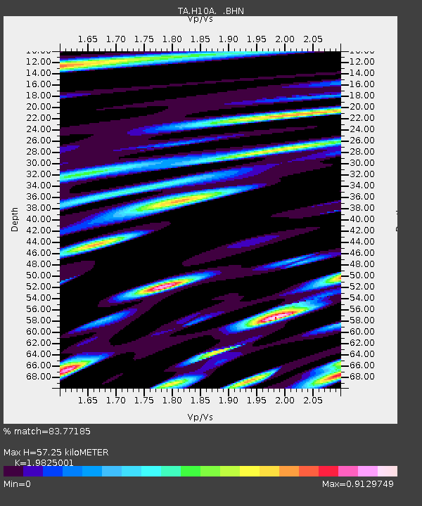
| Estimated Moho Depth: |
57.25 km |
| Estimated Crust Vp/Vs: |
1.98 |
| Assumed Crust Vp: |
6.571 km/s |
| Estimated Crust Vs: |
3.314 km/s |
| Estimated Crust Poisson's Ratio: |
0.33 |
|
| Radial Match: |
83.77185 % |
| Radial Bump: |
400 |
| Transverse Match: |
76.15133 % |
| Transverse Bump: |
400 |
| SOD ConfigId: |
2564 |
| Insert Time: |
2010-03-07 04:17:58.178 +0000 |
| GWidth: |
2.5 |
| Max Bumps: |
400 |
| Tol: |
0.001 |
|
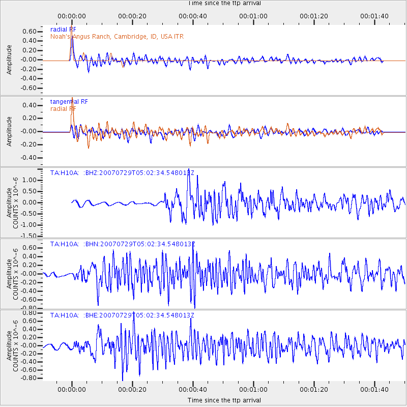
Signal To Noise
| Channel | StoN | STA | LTA |
| TA:H10A: :BHN:20070729T05:02:34.548013Z | 2.220634 | 9.404177E-8 | 4.2349065E-8 |
| TA:H10A: :BHE:20070729T05:02:34.548013Z | 1.4693797 | 7.676457E-8 | 5.2242843E-8 |
| TA:H10A: :BHZ:20070729T05:02:34.548013Z | 4.305553 | 3.0997188E-7 | 7.199352E-8 |
| Arrivals |
| Ps | 9.1 SECOND |
| PpPs | 25 SECOND |
| PsPs/PpSs | 34 SECOND |


