You are here: Home > Network List > TA - USArray Transportable Network (new EarthScope stations) Stations List
> Station H10A Noah's Angus Ranch, Cambridge, ID, USA > Earthquake Result Viewer
H10A Noah's Angus Ranch, Cambridge, ID, USA - Earthquake Result Viewer

| Earthquake location: |
Near Coast Of Guatemala |
| Earthquake latitude/longitude: |
13.8/-90.8 |
| Earthquake time(UTC): |
2007/06/08 (159) 13:32:00 GMT |
| Earthquake Depth: |
48 km |
| Earthquake Magnitude: |
5.5 MB, 5.4 MS, 5.8 MW, 5.8 MW |
| Earthquake Catalog/Contributor: |
WHDF/NEIC |
|
| Network: |
TA USArray Transportable Network (new EarthScope stations) |
| Station: |
H10A Noah's Angus Ranch, Cambridge, ID, USA |
| Lat/Lon: |
44.59 N/116.75 W |
| Elevation: |
882 m |
|
| Distance: |
37.8 deg |
| Az: |
329.29 deg |
| Baz: |
136.031 deg |
| Ray Param: |
0.07580803 |
| Estimated Moho Depth: |
24.75 km |
| Estimated Crust Vp/Vs: |
2.10 |
| Assumed Crust Vp: |
6.571 km/s |
| Estimated Crust Vs: |
3.133 km/s |
| Estimated Crust Poisson's Ratio: |
0.35 |
|
| Radial Match: |
83.479416 % |
| Radial Bump: |
400 |
| Transverse Match: |
74.101524 % |
| Transverse Bump: |
400 |
| SOD ConfigId: |
2564 |
| Insert Time: |
2010-03-07 04:18:11.769 +0000 |
| GWidth: |
2.5 |
| Max Bumps: |
400 |
| Tol: |
0.001 |
|
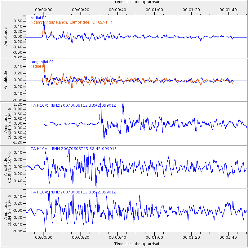
Signal To Noise
| Channel | StoN | STA | LTA |
| TA:H10A: :BHN:20070608T13:38:42.09901Z | 5.8985434 | 2.326119E-7 | 3.943548E-8 |
| TA:H10A: :BHE:20070608T13:38:42.09901Z | 6.07795 | 2.885347E-7 | 4.7472373E-8 |
| TA:H10A: :BHZ:20070608T13:38:42.09901Z | 9.523212 | 5.413948E-7 | 5.6850016E-8 |
| Arrivals |
| Ps | 4.4 SECOND |
| PpPs | 11 SECOND |
| PsPs/PpSs | 15 SECOND |


