You are here: Home > Network List > US - United States National Seismic Network Stations List
> Station HAWA Hanford, Washington, USA > Earthquake Result Viewer
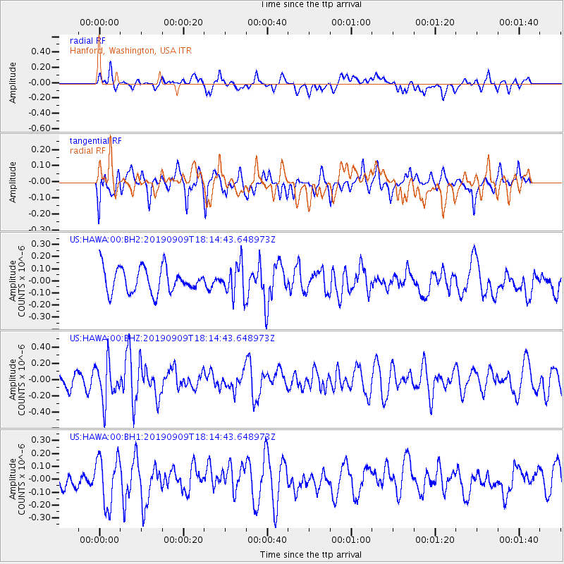
HAWA Hanford, Washington, USA - Earthquake Result Viewer
*The percent match for this event was below the threshold and hence no stack was calculated.
| Earthquake location: |
Near Coast Of Venezuela |
| Earthquake latitude/longitude: |
10.5/-64.4 |
| Earthquake time(UTC): |
2019/09/09 (252) 18:05:17 GMT |
| Earthquake Depth: |
10 km |
| Earthquake Magnitude: |
5.5 Mww |
| Earthquake Catalog/Contributor: |
NEIC PDE/us |
|
| Network: |
US United States National Seismic Network |
| Station: |
HAWA Hanford, Washington, USA |
| Lat/Lon: |
46.39 N/119.53 W |
| Elevation: |
364 m |
|
| Distance: |
58.7 deg |
| Az: |
318.357 deg |
| Baz: |
109.221 deg |
| Ray Param: |
$rayparam |
*The percent match for this event was below the threshold and hence was not used in the summary stack. |
|
| Radial Match: |
52.967308 % |
| Radial Bump: |
400 |
| Transverse Match: |
46.893272 % |
| Transverse Bump: |
400 |
| SOD ConfigId: |
19053131 |
| Insert Time: |
2019-09-23 18:16:30.382 +0000 |
| GWidth: |
2.5 |
| Max Bumps: |
400 |
| Tol: |
0.001 |
|
Signal To Noise
| Channel | StoN | STA | LTA |
| US:HAWA:00:BHZ:20190909T18:14:43.648973Z | 2.451377 | 2.403659E-7 | 9.805343E-8 |
| US:HAWA:00:BH1:20190909T18:14:43.648973Z | 2.463188 | 1.9238355E-7 | 7.8103476E-8 |
| US:HAWA:00:BH2:20190909T18:14:43.648973Z | 1.3051964 | 1.3402027E-7 | 1.02682066E-7 |
| Arrivals |
| Ps | |
| PpPs | |
| PsPs/PpSs | |


