You are here: Home > Network List > TA - USArray Transportable Network (new EarthScope stations) Stations List
> Station H10A Noah's Angus Ranch, Cambridge, ID, USA > Earthquake Result Viewer
H10A Noah's Angus Ranch, Cambridge, ID, USA - Earthquake Result Viewer
| Earthquake location: |
Rat Islands, Aleutian Islands |
| Earthquake latitude/longitude: |
51.2/178.8 |
| Earthquake time(UTC): |
2008/05/20 (141) 13:53:35 GMT |
| Earthquake Depth: |
27 km |
| Earthquake Magnitude: |
5.8 MB, 6.0 MS, 6.3 MW, 6.3 MW |
| Earthquake Catalog/Contributor: |
WHDF/NEIC |
|
| Network: |
TA USArray Transportable Network (new EarthScope stations) |
| Station: |
H10A Noah's Angus Ranch, Cambridge, ID, USA |
| Lat/Lon: |
44.59 N/116.75 W |
| Elevation: |
882 m |
|
| Distance: |
42.5 deg |
| Az: |
72.647 deg |
| Baz: |
302.738 deg |
| Ray Param: |
0.07309342 |
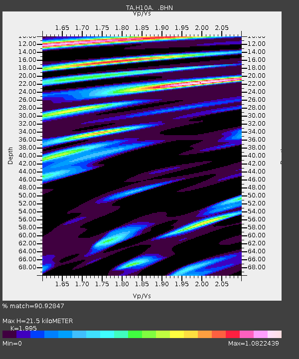
| Estimated Moho Depth: |
21.5 km |
| Estimated Crust Vp/Vs: |
2.00 |
| Assumed Crust Vp: |
6.571 km/s |
| Estimated Crust Vs: |
3.294 km/s |
| Estimated Crust Poisson's Ratio: |
0.33 |
|
| Radial Match: |
90.92847 % |
| Radial Bump: |
400 |
| Transverse Match: |
77.03822 % |
| Transverse Bump: |
400 |
| SOD ConfigId: |
2504 |
| Insert Time: |
2010-03-07 04:18:35.408 +0000 |
| GWidth: |
2.5 |
| Max Bumps: |
400 |
| Tol: |
0.001 |
|

Signal To Noise
| Channel | StoN | STA | LTA |
| TA:H10A: :BHN:20080520T14:00:57.90001Z | 7.8425546 | 8.506583E-7 | 1.0846699E-7 |
| TA:H10A: :BHE:20080520T14:00:57.90001Z | 4.6182513 | 3.0388958E-7 | 6.580187E-8 |
| TA:H10A: :BHZ:20080520T14:00:57.90001Z | 3.031292 | 2.4741712E-7 | 8.162101E-8 |
| Arrivals |
| Ps | 3.5 SECOND |
| PpPs | 9.2 SECOND |
| PsPs/PpSs | 13 SECOND |


