You are here: Home > Network List > TA - USArray Transportable Network (new EarthScope stations) Stations List
> Station H10A Noah's Angus Ranch, Cambridge, ID, USA > Earthquake Result Viewer
H10A Noah's Angus Ranch, Cambridge, ID, USA - Earthquake Result Viewer
| Earthquake location: |
South Of Panama |
| Earthquake latitude/longitude: |
5.0/-82.7 |
| Earthquake time(UTC): |
2008/06/17 (169) 17:42:09 GMT |
| Earthquake Depth: |
10 km |
| Earthquake Magnitude: |
5.6 MB, 5.3 MS, 5.9 MW, 5.9 MW |
| Earthquake Catalog/Contributor: |
WHDF/NEIC |
|
| Network: |
TA USArray Transportable Network (new EarthScope stations) |
| Station: |
H10A Noah's Angus Ranch, Cambridge, ID, USA |
| Lat/Lon: |
44.59 N/116.75 W |
| Elevation: |
882 m |
|
| Distance: |
49.4 deg |
| Az: |
328.187 deg |
| Baz: |
132.694 deg |
| Ray Param: |
0.06869373 |
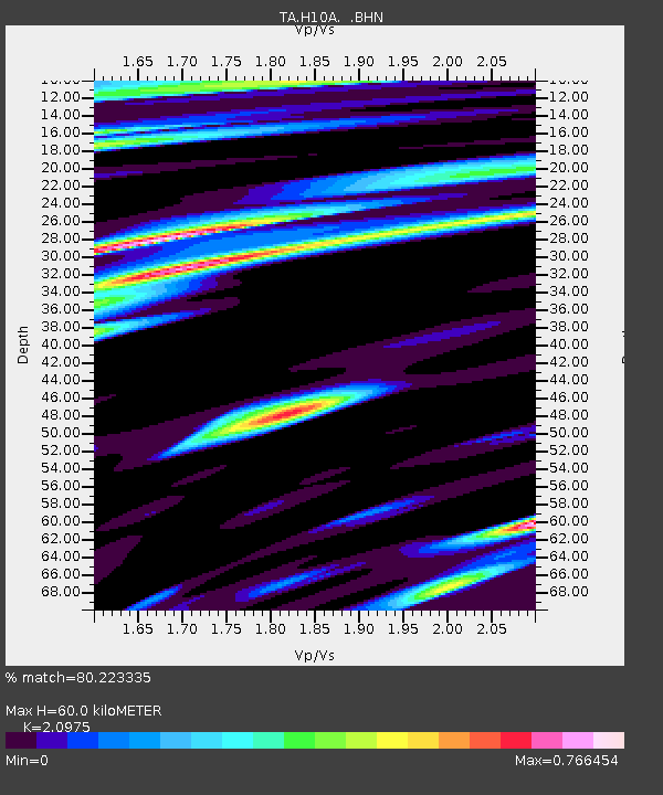
| Estimated Moho Depth: |
60.0 km |
| Estimated Crust Vp/Vs: |
2.10 |
| Assumed Crust Vp: |
6.571 km/s |
| Estimated Crust Vs: |
3.133 km/s |
| Estimated Crust Poisson's Ratio: |
0.35 |
|
| Radial Match: |
80.223335 % |
| Radial Bump: |
400 |
| Transverse Match: |
58.783405 % |
| Transverse Bump: |
400 |
| SOD ConfigId: |
2504 |
| Insert Time: |
2010-03-07 04:18:39.804 +0000 |
| GWidth: |
2.5 |
| Max Bumps: |
400 |
| Tol: |
0.001 |
|
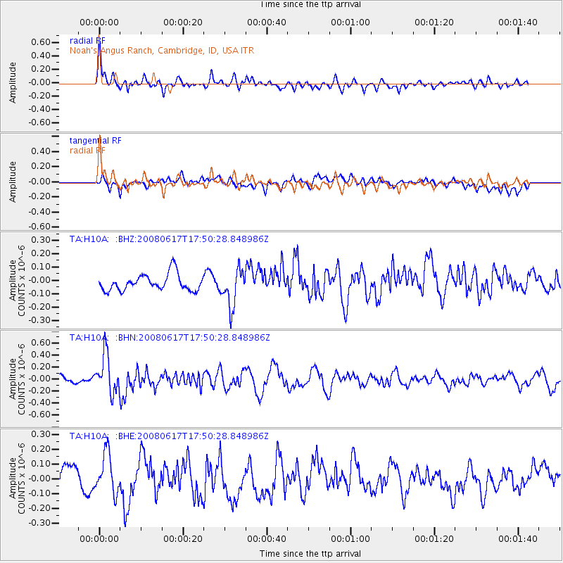
Signal To Noise
| Channel | StoN | STA | LTA |
| TA:H10A: :BHN:20080617T17:50:28.848986Z | 4.3517604 | 3.28829E-7 | 7.556229E-8 |
| TA:H10A: :BHE:20080617T17:50:28.848986Z | 1.9938328 | 1.3975435E-7 | 7.0093314E-8 |
| TA:H10A: :BHZ:20080617T17:50:28.848986Z | 2.2750552 | 1.400018E-7 | 6.153776E-8 |
| Arrivals |
| Ps | 11 SECOND |
| PpPs | 27 SECOND |
| PsPs/PpSs | 37 SECOND |


