You are here: Home > Network List > TA - USArray Transportable Network (new EarthScope stations) Stations List
> Station H10A Noah's Angus Ranch, Cambridge, ID, USA > Earthquake Result Viewer
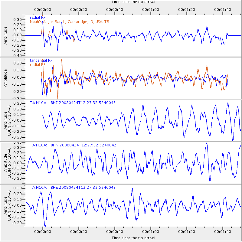
H10A Noah's Angus Ranch, Cambridge, ID, USA - Earthquake Result Viewer
*The percent match for this event was below the threshold and hence no stack was calculated.
| Earthquake location: |
Central Mid-Atlantic Ridge |
| Earthquake latitude/longitude: |
-1.2/-23.5 |
| Earthquake time(UTC): |
2008/04/24 (115) 12:14:49 GMT |
| Earthquake Depth: |
10 km |
| Earthquake Magnitude: |
6.0 MS, 5.4 MB, 6.5 MW, 6.4 MW |
| Earthquake Catalog/Contributor: |
WHDF/NEIC |
|
| Network: |
TA USArray Transportable Network (new EarthScope stations) |
| Station: |
H10A Noah's Angus Ranch, Cambridge, ID, USA |
| Lat/Lon: |
44.59 N/116.75 W |
| Elevation: |
882 m |
|
| Distance: |
93.2 deg |
| Az: |
314.403 deg |
| Baz: |
88.546 deg |
| Ray Param: |
$rayparam |
*The percent match for this event was below the threshold and hence was not used in the summary stack. |
|
| Radial Match: |
36.220444 % |
| Radial Bump: |
349 |
| Transverse Match: |
49.918488 % |
| Transverse Bump: |
400 |
| SOD ConfigId: |
2504 |
| Insert Time: |
2010-03-07 04:18:51.062 +0000 |
| GWidth: |
2.5 |
| Max Bumps: |
400 |
| Tol: |
0.001 |
|
Signal To Noise
| Channel | StoN | STA | LTA |
| TA:H10A: :BHN:20080424T12:27:32.524004Z | 1.2092074 | 1.0952844E-7 | 9.0578716E-8 |
| TA:H10A: :BHE:20080424T12:27:32.524004Z | 3.7440474 | 2.1087976E-7 | 5.632401E-8 |
| TA:H10A: :BHZ:20080424T12:27:32.524004Z | 1.0821879 | 8.293198E-8 | 7.6633626E-8 |
| Arrivals |
| Ps | |
| PpPs | |
| PsPs/PpSs | |


