You are here: Home > Network List > TA - USArray Transportable Network (new EarthScope stations) Stations List
> Station HELL Mitchell Peak, Miramonte, CA, USA > Earthquake Result Viewer
HELL Mitchell Peak, Miramonte, CA, USA - Earthquake Result Viewer
| Earthquake location: |
Tonga Islands |
| Earthquake latitude/longitude: |
-20.4/-174.3 |
| Earthquake time(UTC): |
2005/03/19 (078) 15:02:42 GMT |
| Earthquake Depth: |
18 km |
| Earthquake Magnitude: |
5.9 MB, 5.9 MS, 6.1 MW, 6.0 MW |
| Earthquake Catalog/Contributor: |
WHDF/NEIC |
|
| Network: |
TA USArray Transportable Network (new EarthScope stations) |
| Station: |
HELL Mitchell Peak, Miramonte, CA, USA |
| Lat/Lon: |
36.68 N/119.02 W |
| Elevation: |
1145 m |
|
| Distance: |
77.1 deg |
| Az: |
42.696 deg |
| Baz: |
232.3 deg |
| Ray Param: |
0.050523974 |
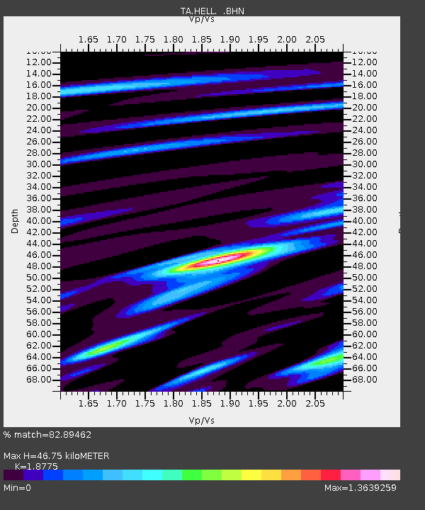
| Estimated Moho Depth: |
46.75 km |
| Estimated Crust Vp/Vs: |
1.88 |
| Assumed Crust Vp: |
6.291 km/s |
| Estimated Crust Vs: |
3.351 km/s |
| Estimated Crust Poisson's Ratio: |
0.30 |
|
| Radial Match: |
82.89462 % |
| Radial Bump: |
400 |
| Transverse Match: |
66.514114 % |
| Transverse Bump: |
400 |
| SOD ConfigId: |
142937 |
| Insert Time: |
2010-03-07 04:19:21.012 +0000 |
| GWidth: |
2.5 |
| Max Bumps: |
400 |
| Tol: |
0.001 |
|
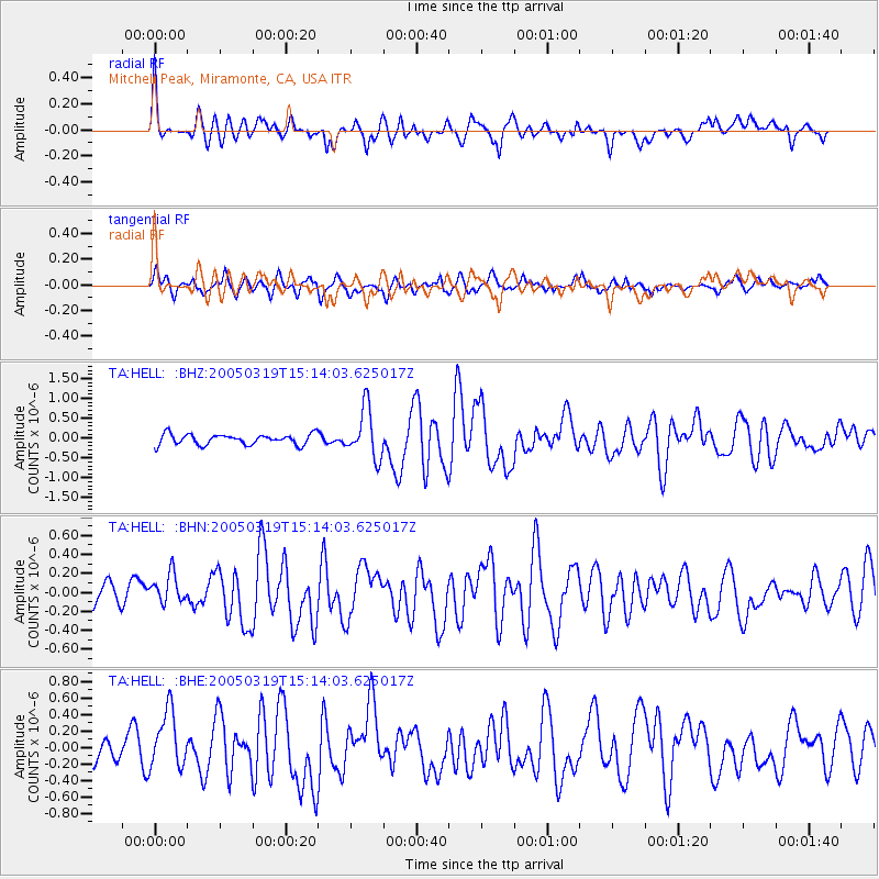
Signal To Noise
| Channel | StoN | STA | LTA |
| TA:HELL: :BHN:20050319T15:14:03.625017Z | 1.4212781 | 1.5434448E-7 | 1.0859554E-7 |
| TA:HELL: :BHE:20050319T15:14:03.625017Z | 2.859879 | 3.4859983E-7 | 1.2189321E-7 |
| TA:HELL: :BHZ:20050319T15:14:03.625017Z | 4.6696367 | 6.18464E-7 | 1.324437E-7 |
| Arrivals |
| Ps | 6.7 SECOND |
| PpPs | 21 SECOND |
| PsPs/PpSs | 28 SECOND |


