You are here: Home > Network List > TA - USArray Transportable Network (new EarthScope stations) Stations List
> Station HELL Mitchell Peak, Miramonte, CA, USA > Earthquake Result Viewer
HELL Mitchell Peak, Miramonte, CA, USA - Earthquake Result Viewer
| Earthquake location: |
Near S. Coast Of Honshu, Japan |
| Earthquake latitude/longitude: |
35.5/140.0 |
| Earthquake time(UTC): |
2005/07/23 (204) 07:34:56 GMT |
| Earthquake Depth: |
61 km |
| Earthquake Magnitude: |
6.1 MB, 6.0 MW, 6.0 MW |
| Earthquake Catalog/Contributor: |
WHDF/NEIC |
|
| Network: |
TA USArray Transportable Network (new EarthScope stations) |
| Station: |
HELL Mitchell Peak, Miramonte, CA, USA |
| Lat/Lon: |
36.68 N/119.02 W |
| Elevation: |
1145 m |
|
| Distance: |
77.4 deg |
| Az: |
53.971 deg |
| Baz: |
304.828 deg |
| Ray Param: |
0.050249208 |
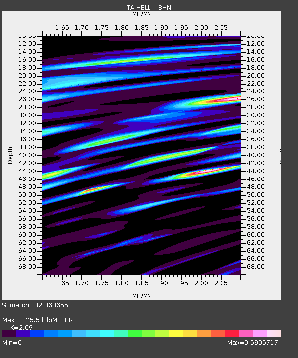
| Estimated Moho Depth: |
25.5 km |
| Estimated Crust Vp/Vs: |
2.09 |
| Assumed Crust Vp: |
6.291 km/s |
| Estimated Crust Vs: |
3.01 km/s |
| Estimated Crust Poisson's Ratio: |
0.35 |
|
| Radial Match: |
82.363655 % |
| Radial Bump: |
400 |
| Transverse Match: |
79.8015 % |
| Transverse Bump: |
400 |
| SOD ConfigId: |
2564 |
| Insert Time: |
2010-03-07 04:19:25.208 +0000 |
| GWidth: |
2.5 |
| Max Bumps: |
400 |
| Tol: |
0.001 |
|
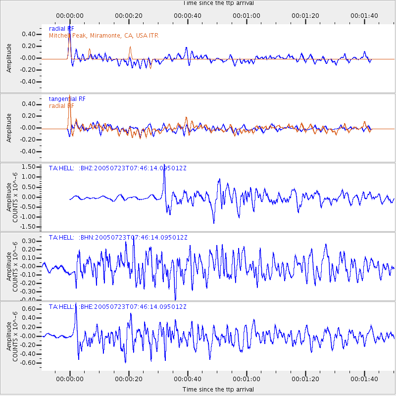
Signal To Noise
| Channel | StoN | STA | LTA |
| TA:HELL: :BHN:20050723T07:46:14.095012Z | 2.5967128 | 1.03778866E-7 | 3.9965474E-8 |
| TA:HELL: :BHE:20050723T07:46:14.095012Z | 5.1410513 | 2.6400147E-7 | 5.1351652E-8 |
| TA:HELL: :BHZ:20050723T07:46:14.095012Z | 7.7349825 | 5.492119E-7 | 7.100363E-8 |
| Arrivals |
| Ps | 4.5 SECOND |
| PpPs | 12 SECOND |
| PsPs/PpSs | 17 SECOND |


