You are here: Home > Network List > TA - USArray Transportable Network (new EarthScope stations) Stations List
> Station F21K Alatna River, AK, USA > Earthquake Result Viewer
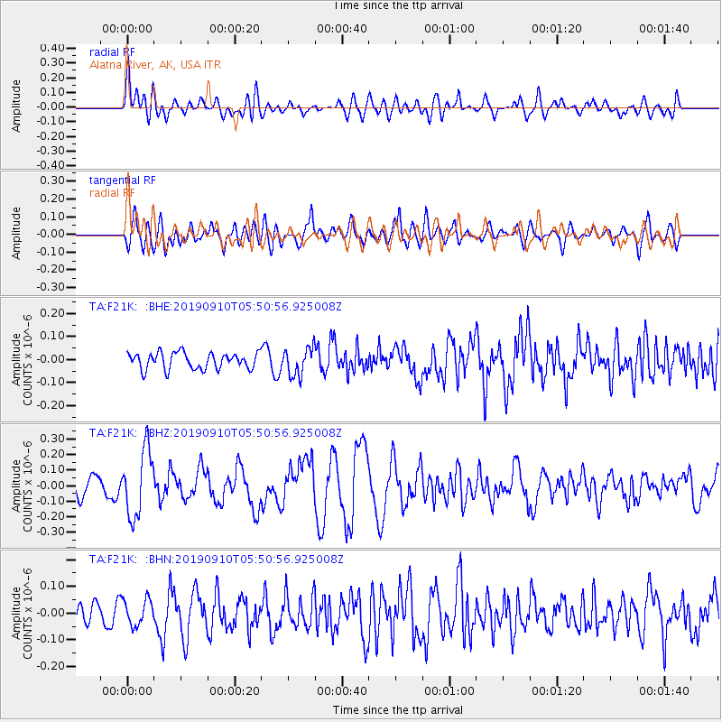
F21K Alatna River, AK, USA - Earthquake Result Viewer
*The percent match for this event was below the threshold and hence no stack was calculated.
| Earthquake location: |
Mindanao, Philippines |
| Earthquake latitude/longitude: |
6.7/126.5 |
| Earthquake time(UTC): |
2019/09/10 (253) 05:39:24 GMT |
| Earthquake Depth: |
56 km |
| Earthquake Magnitude: |
5.6 Mww |
| Earthquake Catalog/Contributor: |
NEIC PDE/us |
|
| Network: |
TA USArray Transportable Network (new EarthScope stations) |
| Station: |
F21K Alatna River, AK, USA |
| Lat/Lon: |
67.22 N/153.48 W |
| Elevation: |
597 m |
|
| Distance: |
80.0 deg |
| Az: |
22.919 deg |
| Baz: |
263.414 deg |
| Ray Param: |
$rayparam |
*The percent match for this event was below the threshold and hence was not used in the summary stack. |
|
| Radial Match: |
68.087776 % |
| Radial Bump: |
400 |
| Transverse Match: |
57.471703 % |
| Transverse Bump: |
400 |
| SOD ConfigId: |
19053131 |
| Insert Time: |
2019-09-24 05:44:25.206 +0000 |
| GWidth: |
2.5 |
| Max Bumps: |
400 |
| Tol: |
0.001 |
|
Signal To Noise
| Channel | StoN | STA | LTA |
| TA:F21K: :BHZ:20190910T05:50:56.925008Z | 4.3527484 | 2.1599921E-7 | 4.9623637E-8 |
| TA:F21K: :BHN:20190910T05:50:56.925008Z | 0.835363 | 4.797996E-8 | 5.7436065E-8 |
| TA:F21K: :BHE:20190910T05:50:56.925008Z | 1.7244185 | 6.122228E-8 | 3.550314E-8 |
| Arrivals |
| Ps | |
| PpPs | |
| PsPs/PpSs | |


