You are here: Home > Network List > TA - USArray Transportable Network (new EarthScope stations) Stations List
> Station HELL Mitchell Peak, Miramonte, CA, USA > Earthquake Result Viewer
HELL Mitchell Peak, Miramonte, CA, USA - Earthquake Result Viewer

| Earthquake location: |
Eastern New Guinea Reg., P.N.G. |
| Earthquake latitude/longitude: |
-5.2/145.3 |
| Earthquake time(UTC): |
2005/11/22 (326) 15:11:31 GMT |
| Earthquake Depth: |
68 km |
| Earthquake Magnitude: |
6.0 MB, 6.2 MW, 6.2 MW |
| Earthquake Catalog/Contributor: |
WHDF/NEIC |
|
| Network: |
TA USArray Transportable Network (new EarthScope stations) |
| Station: |
HELL Mitchell Peak, Miramonte, CA, USA |
| Lat/Lon: |
36.68 N/119.02 W |
| Elevation: |
1145 m |
|
| Distance: |
97.6 deg |
| Az: |
53.809 deg |
| Baz: |
269.25 deg |
| Ray Param: |
0.040112175 |
| Estimated Moho Depth: |
66.25 km |
| Estimated Crust Vp/Vs: |
1.99 |
| Assumed Crust Vp: |
6.291 km/s |
| Estimated Crust Vs: |
3.165 km/s |
| Estimated Crust Poisson's Ratio: |
0.33 |
|
| Radial Match: |
86.996086 % |
| Radial Bump: |
400 |
| Transverse Match: |
39.888493 % |
| Transverse Bump: |
400 |
| SOD ConfigId: |
132717 |
| Insert Time: |
2010-03-07 04:19:31.436 +0000 |
| GWidth: |
2.5 |
| Max Bumps: |
400 |
| Tol: |
0.001 |
|
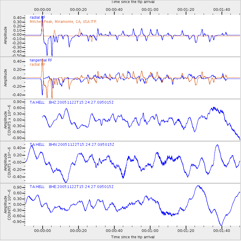
Signal To Noise
| Channel | StoN | STA | LTA |
| TA:HELL: :BHN:20051122T15:24:27.095015Z | 0.4925735 | 1.804512E-7 | 3.663437E-7 |
| TA:HELL: :BHE:20051122T15:24:27.095015Z | 0.8834781 | 1.6932174E-7 | 1.9165357E-7 |
| TA:HELL: :BHZ:20051122T15:24:27.095015Z | 0.33156928 | 8.765878E-8 | 2.6437547E-7 |
| Arrivals |
| Ps | 11 SECOND |
| PpPs | 31 SECOND |
| PsPs/PpSs | 42 SECOND |


