You are here: Home > Network List > TA - USArray Transportable Network (new EarthScope stations) Stations List
> Station HELL Mitchell Peak, Miramonte, CA, USA > Earthquake Result Viewer
HELL Mitchell Peak, Miramonte, CA, USA - Earthquake Result Viewer
| Earthquake location: |
Peru-Ecuador Border Region |
| Earthquake latitude/longitude: |
-3.3/-81.0 |
| Earthquake time(UTC): |
2005/05/21 (141) 05:11:35 GMT |
| Earthquake Depth: |
40 km |
| Earthquake Magnitude: |
5.9 MB, 5.9 MS, 6.4 MW, 6.3 MW |
| Earthquake Catalog/Contributor: |
WHDF/NEIC |
|
| Network: |
TA USArray Transportable Network (new EarthScope stations) |
| Station: |
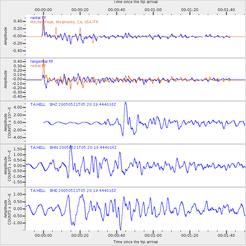
HELL Mitchell Peak, Miramonte, CA, USA |
| Lat/Lon: |
36.68 N/119.02 W |
| Elevation: |
1145 m |
|
| Distance: |
53.3 deg |
| Az: |
321.818 deg |
| Baz: |
129.852 deg |
| Ray Param: |
0.066138 |
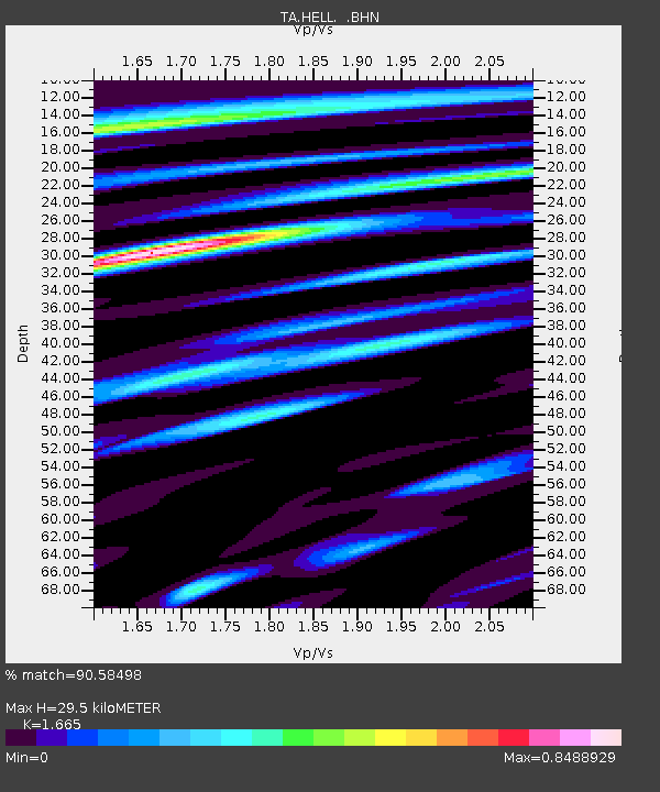
| Estimated Moho Depth: |
29.5 km |
| Estimated Crust Vp/Vs: |
1.66 |
| Assumed Crust Vp: |
6.291 km/s |
| Estimated Crust Vs: |
3.779 km/s |
| Estimated Crust Poisson's Ratio: |
0.22 |
|
| Radial Match: |
90.58498 % |
| Radial Bump: |
400 |
| Transverse Match: |
79.580505 % |
| Transverse Bump: |
400 |
| SOD ConfigId: |
132717 |
| Insert Time: |
2010-03-07 04:19:33.203 +0000 |
| GWidth: |
2.5 |
| Max Bumps: |
400 |
| Tol: |
0.001 |
|
Signal To Noise
| Channel | StoN | STA | LTA |
| TA:HELL: :BHN:20050521T05:20:19.444016Z | 1.4356396 | 2.6263214E-7 | 1.8293737E-7 |
| TA:HELL: :BHE:20050521T05:20:19.444016Z | 1.0958576 | 2.0902891E-7 | 1.9074459E-7 |
| TA:HELL: :BHZ:20050521T05:20:19.444016Z | 1.1734192 | 2.4796591E-7 | 2.113191E-7 |
| Arrivals |
| Ps | 3.3 SECOND |
| PpPs | 12 SECOND |
| PsPs/PpSs | 15 SECOND |


