You are here: Home > Network List > TA - USArray Transportable Network (new EarthScope stations) Stations List
> Station HELL Mitchell Peak, Miramonte, CA, USA > Earthquake Result Viewer
HELL Mitchell Peak, Miramonte, CA, USA - Earthquake Result Viewer
| Earthquake location: |
Unimak Island Region, Alaska |
| Earthquake latitude/longitude: |
53.8/-164.1 |
| Earthquake time(UTC): |
2005/11/20 (324) 12:53:02 GMT |
| Earthquake Depth: |
30 km |
| Earthquake Magnitude: |
5.7 MB, 5.8 MS, 6.2 MW, 6.0 MW |
| Earthquake Catalog/Contributor: |
WHDF/NEIC |
|
| Network: |
TA USArray Transportable Network (new EarthScope stations) |
| Station: |
HELL Mitchell Peak, Miramonte, CA, USA |
| Lat/Lon: |
36.68 N/119.02 W |
| Elevation: |
1145 m |
|
| Distance: |
35.4 deg |
| Az: |
100.441 deg |
| Baz: |
313.537 deg |
| Ray Param: |
0.07721246 |
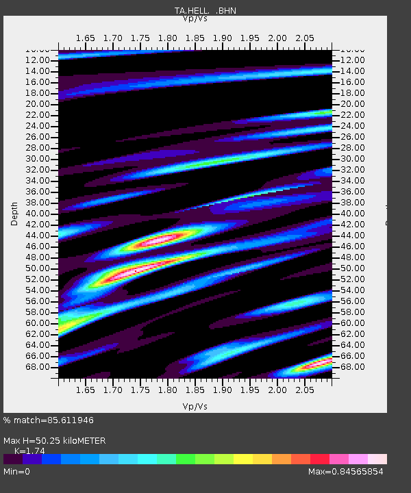
| Estimated Moho Depth: |
50.25 km |
| Estimated Crust Vp/Vs: |
1.74 |
| Assumed Crust Vp: |
6.291 km/s |
| Estimated Crust Vs: |
3.616 km/s |
| Estimated Crust Poisson's Ratio: |
0.25 |
|
| Radial Match: |
85.611946 % |
| Radial Bump: |
400 |
| Transverse Match: |
74.03796 % |
| Transverse Bump: |
400 |
| SOD ConfigId: |
2448 |
| Insert Time: |
2010-03-07 04:19:37.551 +0000 |
| GWidth: |
2.5 |
| Max Bumps: |
400 |
| Tol: |
0.001 |
|
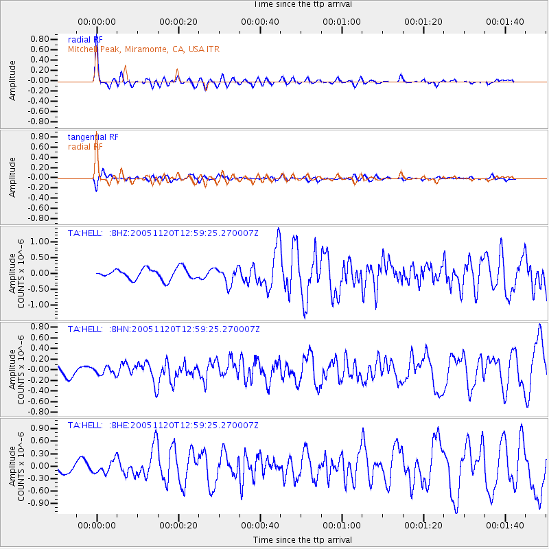
Signal To Noise
| Channel | StoN | STA | LTA |
| TA:HELL: :BHN:20051120T12:59:25.270007Z | 0.67205405 | 6.8100995E-8 | 1.0133262E-7 |
| TA:HELL: :BHE:20051120T12:59:25.270007Z | 1.2456658 | 1.5330654E-7 | 1.2307197E-7 |
| TA:HELL: :BHZ:20051120T12:59:25.270007Z | 1.5910134 | 2.687813E-7 | 1.6893716E-7 |
| Arrivals |
| Ps | 6.4 SECOND |
| PpPs | 20 SECOND |
| PsPs/PpSs | 27 SECOND |


