You are here: Home > Network List > TA - USArray Transportable Network (new EarthScope stations) Stations List
> Station HELL Mitchell Peak, Miramonte, CA, USA > Earthquake Result Viewer
HELL Mitchell Peak, Miramonte, CA, USA - Earthquake Result Viewer

| Earthquake location: |
Off East Coast Of Honshu, Japan |
| Earthquake latitude/longitude: |
38.1/144.9 |
| Earthquake time(UTC): |
2005/11/14 (318) 21:38:51 GMT |
| Earthquake Depth: |
11 km |
| Earthquake Magnitude: |
6.7 MB, 6.8 MS, 7.0 MW, 6.9 MW |
| Earthquake Catalog/Contributor: |
WHDF/NEIC |
|
| Network: |
TA USArray Transportable Network (new EarthScope stations) |
| Station: |
HELL Mitchell Peak, Miramonte, CA, USA |
| Lat/Lon: |
36.68 N/119.02 W |
| Elevation: |
1145 m |
|
| Distance: |
72.6 deg |
| Az: |
56.879 deg |
| Baz: |
304.729 deg |
| Ray Param: |
0.053524286 |
| Estimated Moho Depth: |
25.75 km |
| Estimated Crust Vp/Vs: |
2.10 |
| Assumed Crust Vp: |
6.291 km/s |
| Estimated Crust Vs: |
2.999 km/s |
| Estimated Crust Poisson's Ratio: |
0.35 |
|
| Radial Match: |
95.409004 % |
| Radial Bump: |
310 |
| Transverse Match: |
93.72771 % |
| Transverse Bump: |
400 |
| SOD ConfigId: |
2448 |
| Insert Time: |
2010-03-07 04:19:38.855 +0000 |
| GWidth: |
2.5 |
| Max Bumps: |
400 |
| Tol: |
0.001 |
|
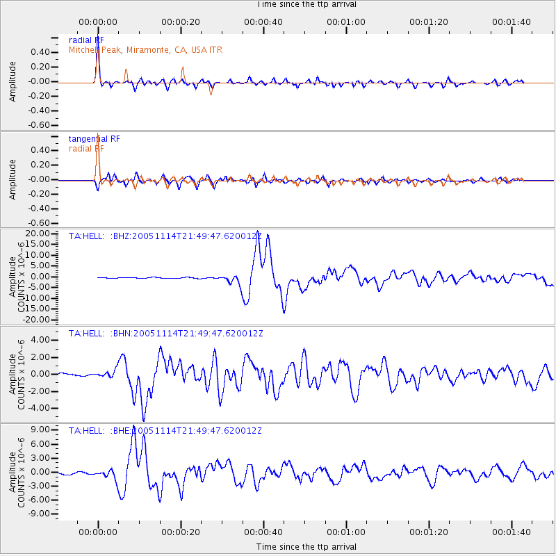
Signal To Noise
| Channel | StoN | STA | LTA |
| TA:HELL: :BHN:20051114T21:49:47.620012Z | 3.7280912 | 4.4144195E-7 | 1.18409645E-7 |
| TA:HELL: :BHE:20051114T21:49:47.620012Z | 6.1003356 | 1.041989E-6 | 1.7080845E-7 |
| TA:HELL: :BHZ:20051114T21:49:47.620012Z | 12.597116 | 2.4037722E-6 | 1.9081924E-7 |
| Arrivals |
| Ps | 4.6 SECOND |
| PpPs | 12 SECOND |
| PsPs/PpSs | 17 SECOND |


