You are here: Home > Network List > TA - USArray Transportable Network (new EarthScope stations) Stations List
> Station I27K Kandik River, AK, USA > Earthquake Result Viewer
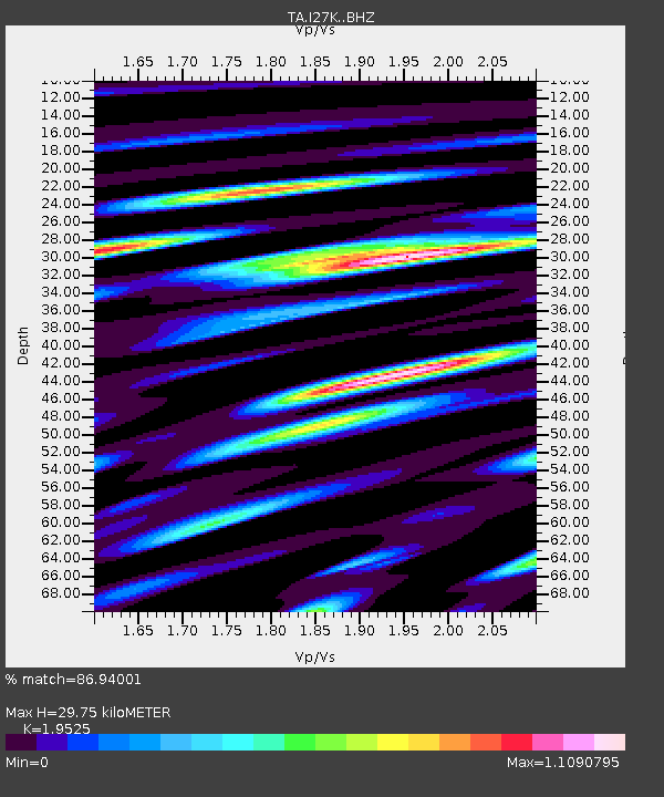
I27K Kandik River, AK, USA - Earthquake Result Viewer
| Earthquake location: |
Mindanao, Philippines |
| Earthquake latitude/longitude: |
6.7/126.5 |
| Earthquake time(UTC): |
2019/09/10 (253) 05:39:24 GMT |
| Earthquake Depth: |
56 km |
| Earthquake Magnitude: |
5.6 Mww |
| Earthquake Catalog/Contributor: |
NEIC PDE/us |
|
| Network: |
TA USArray Transportable Network (new EarthScope stations) |
| Station: |
I27K Kandik River, AK, USA |
| Lat/Lon: |
65.60 N/141.62 W |
| Elevation: |
874 m |
|
| Distance: |
84.7 deg |
| Az: |
24.638 deg |
| Baz: |
274.514 deg |
| Ray Param: |
0.045167003 |
| Estimated Moho Depth: |
29.75 km |
| Estimated Crust Vp/Vs: |
1.95 |
| Assumed Crust Vp: |
6.566 km/s |
| Estimated Crust Vs: |
3.363 km/s |
| Estimated Crust Poisson's Ratio: |
0.32 |
|
| Radial Match: |
86.94001 % |
| Radial Bump: |
400 |
| Transverse Match: |
83.757484 % |
| Transverse Bump: |
400 |
| SOD ConfigId: |
19053131 |
| Insert Time: |
2019-09-24 05:44:46.293 +0000 |
| GWidth: |
2.5 |
| Max Bumps: |
400 |
| Tol: |
0.001 |
|

Signal To Noise
| Channel | StoN | STA | LTA |
| TA:I27K: :BHZ:20190910T05:51:21.550008Z | 10.431584 | 7.7975517E-7 | 7.474945E-8 |
| TA:I27K: :BHN:20190910T05:51:21.550008Z | 2.6907527 | 1.6135827E-7 | 5.996771E-8 |
| TA:I27K: :BHE:20190910T05:51:21.550008Z | 3.673579 | 2.8027637E-7 | 7.629518E-8 |
| Arrivals |
| Ps | 4.4 SECOND |
| PpPs | 13 SECOND |
| PsPs/PpSs | 17 SECOND |


