You are here: Home > Network List > TA - USArray Transportable Network (new EarthScope stations) Stations List
> Station HELL Mitchell Peak, Miramonte, CA, USA > Earthquake Result Viewer
HELL Mitchell Peak, Miramonte, CA, USA - Earthquake Result Viewer

| Earthquake location: |
South Of Kermadec Islands |
| Earthquake latitude/longitude: |
-32.6/-179.4 |
| Earthquake time(UTC): |
2005/05/16 (136) 03:54:14 GMT |
| Earthquake Depth: |
34 km |
| Earthquake Magnitude: |
6.2 MB, 6.4 MS, 6.6 MW, 6.6 MW |
| Earthquake Catalog/Contributor: |
WHDF/NEIC |
|
| Network: |
TA USArray Transportable Network (new EarthScope stations) |
| Station: |
HELL Mitchell Peak, Miramonte, CA, USA |
| Lat/Lon: |
36.68 N/119.02 W |
| Elevation: |
1145 m |
|
| Distance: |
89.0 deg |
| Az: |
44.315 deg |
| Baz: |
227.191 deg |
| Ray Param: |
0.042112168 |
| Estimated Moho Depth: |
45.75 km |
| Estimated Crust Vp/Vs: |
1.89 |
| Assumed Crust Vp: |
6.291 km/s |
| Estimated Crust Vs: |
3.333 km/s |
| Estimated Crust Poisson's Ratio: |
0.30 |
|
| Radial Match: |
92.111534 % |
| Radial Bump: |
400 |
| Transverse Match: |
89.43544 % |
| Transverse Bump: |
400 |
| SOD ConfigId: |
142939 |
| Insert Time: |
2010-03-07 04:19:39.787 +0000 |
| GWidth: |
2.5 |
| Max Bumps: |
400 |
| Tol: |
0.001 |
|
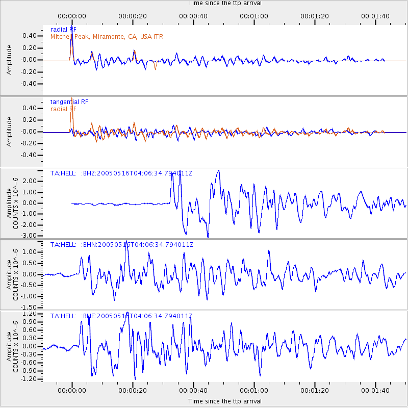
Signal To Noise
| Channel | StoN | STA | LTA |
| TA:HELL: :BHN:20050516T04:06:34.794011Z | 4.950783 | 2.9379498E-7 | 5.934314E-8 |
| TA:HELL: :BHE:20050516T04:06:34.794011Z | 5.537502 | 3.249153E-7 | 5.8675433E-8 |
| TA:HELL: :BHZ:20050516T04:06:34.794011Z | 21.481249 | 9.888564E-7 | 4.6033467E-8 |
| Arrivals |
| Ps | 6.6 SECOND |
| PpPs | 21 SECOND |
| PsPs/PpSs | 27 SECOND |


