You are here: Home > Network List > TA - USArray Transportable Network (new EarthScope stations) Stations List
> Station L16K Owhat River, AK, USA > Earthquake Result Viewer
L16K Owhat River, AK, USA - Earthquake Result Viewer
| Earthquake location: |
Mindanao, Philippines |
| Earthquake latitude/longitude: |
6.7/126.5 |
| Earthquake time(UTC): |
2019/09/10 (253) 05:39:24 GMT |
| Earthquake Depth: |
56 km |
| Earthquake Magnitude: |
5.6 Mww |
| Earthquake Catalog/Contributor: |
NEIC PDE/us |
|
| Network: |
TA USArray Transportable Network (new EarthScope stations) |
| Station: |
L16K Owhat River, AK, USA |
| Lat/Lon: |
61.71 N/159.47 W |
| Elevation: |
227 m |
|
| Distance: |
76.6 deg |
| Az: |
28.094 deg |
| Baz: |
259.058 deg |
| Ray Param: |
0.05078622 |
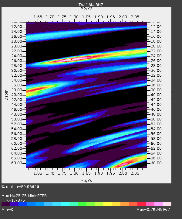
| Estimated Moho Depth: |
25.25 km |
| Estimated Crust Vp/Vs: |
1.79 |
| Assumed Crust Vp: |
6.276 km/s |
| Estimated Crust Vs: |
3.511 km/s |
| Estimated Crust Poisson's Ratio: |
0.27 |
|
| Radial Match: |
80.95646 % |
| Radial Bump: |
392 |
| Transverse Match: |
57.079426 % |
| Transverse Bump: |
400 |
| SOD ConfigId: |
19053131 |
| Insert Time: |
2019-09-24 05:44:58.627 +0000 |
| GWidth: |
2.5 |
| Max Bumps: |
400 |
| Tol: |
0.001 |
|

Signal To Noise
| Channel | StoN | STA | LTA |
| TA:L16K: :BHZ:20190910T05:50:38.175008Z | 4.167654 | 2.8359344E-7 | 6.8046305E-8 |
| TA:L16K: :BHN:20190910T05:50:38.175008Z | 0.9661316 | 6.105065E-8 | 6.319082E-8 |
| TA:L16K: :BHE:20190910T05:50:38.175008Z | 2.2948318 | 1.5135646E-7 | 6.595536E-8 |
| Arrivals |
| Ps | 3.3 SECOND |
| PpPs | 11 SECOND |
| PsPs/PpSs | 14 SECOND |


