You are here: Home > Network List > TA - USArray Transportable Network (new EarthScope stations) Stations List
> Station HELL Mitchell Peak, Miramonte, CA, USA > Earthquake Result Viewer
HELL Mitchell Peak, Miramonte, CA, USA - Earthquake Result Viewer
| Earthquake location: |
Near East Coast Of Kamchatka |
| Earthquake latitude/longitude: |
55.6/161.7 |
| Earthquake time(UTC): |
2006/08/17 (229) 11:11:35 GMT |
| Earthquake Depth: |
55 km |
| Earthquake Magnitude: |
6.1 MB, 5.7 MW, 5.7 MW |
| Earthquake Catalog/Contributor: |
WHDF/NEIC |
|
| Network: |
TA USArray Transportable Network (new EarthScope stations) |
| Station: |
HELL Mitchell Peak, Miramonte, CA, USA |
| Lat/Lon: |
36.68 N/119.02 W |
| Elevation: |
1145 m |
|
| Distance: |
54.9 deg |
| Az: |
74.814 deg |
| Baz: |
317.074 deg |
| Ray Param: |
0.064987026 |
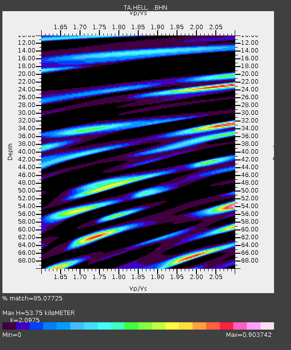
| Estimated Moho Depth: |
53.75 km |
| Estimated Crust Vp/Vs: |
2.10 |
| Assumed Crust Vp: |
6.291 km/s |
| Estimated Crust Vs: |
2.999 km/s |
| Estimated Crust Poisson's Ratio: |
0.35 |
|
| Radial Match: |
85.07725 % |
| Radial Bump: |
400 |
| Transverse Match: |
80.641266 % |
| Transverse Bump: |
400 |
| SOD ConfigId: |
2564 |
| Insert Time: |
2010-03-07 04:19:53.650 +0000 |
| GWidth: |
2.5 |
| Max Bumps: |
400 |
| Tol: |
0.001 |
|
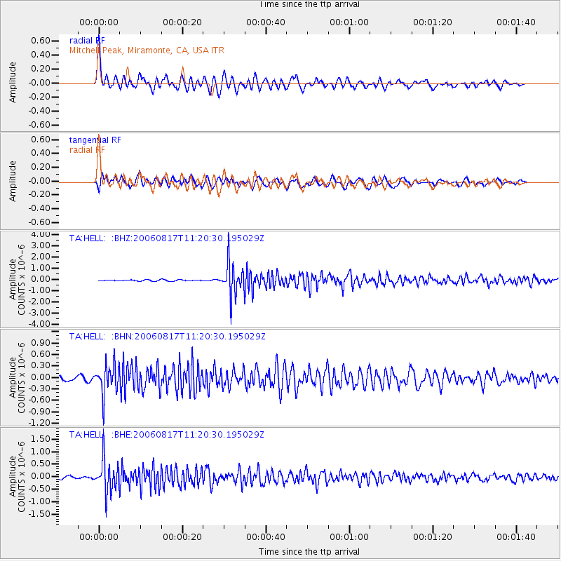
Signal To Noise
| Channel | StoN | STA | LTA |
| TA:HELL: :BHN:20060817T11:20:30.195029Z | 7.681847 | 3.993608E-7 | 5.19876E-8 |
| TA:HELL: :BHE:20060817T11:20:30.195029Z | 11.670904 | 6.4419135E-7 | 5.5196352E-8 |
| TA:HELL: :BHZ:20060817T11:20:30.195029Z | 24.55843 | 1.4064209E-6 | 5.7268355E-8 |
| Arrivals |
| Ps | 9.8 SECOND |
| PpPs | 25 SECOND |
| PsPs/PpSs | 35 SECOND |


