You are here: Home > Network List > TA - USArray Transportable Network (new EarthScope stations) Stations List
> Station HELL Mitchell Peak, Miramonte, CA, USA > Earthquake Result Viewer
HELL Mitchell Peak, Miramonte, CA, USA - Earthquake Result Viewer
| Earthquake location: |
Panama-Costa Rica Border Region |
| Earthquake latitude/longitude: |
8.2/-82.9 |
| Earthquake time(UTC): |
2006/05/01 (121) 07:47:59 GMT |
| Earthquake Depth: |
13 km |
| Earthquake Magnitude: |
5.1 MB, 5.6 MS, 5.9 MW, 5.9 MW |
| Earthquake Catalog/Contributor: |
WHDF/NEIC |
|
| Network: |
TA USArray Transportable Network (new EarthScope stations) |
| Station: |
HELL Mitchell Peak, Miramonte, CA, USA |
| Lat/Lon: |
36.68 N/119.02 W |
| Elevation: |
1145 m |
|
| Distance: |
43.4 deg |
| Az: |
316.362 deg |
| Baz: |
121.805 deg |
| Ray Param: |
0.07257171 |
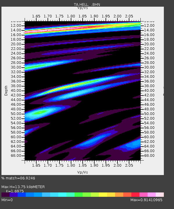
| Estimated Moho Depth: |
13.75 km |
| Estimated Crust Vp/Vs: |
1.70 |
| Assumed Crust Vp: |
6.291 km/s |
| Estimated Crust Vs: |
3.706 km/s |
| Estimated Crust Poisson's Ratio: |
0.23 |
|
| Radial Match: |
86.9246 % |
| Radial Bump: |
308 |
| Transverse Match: |
83.58981 % |
| Transverse Bump: |
400 |
| SOD ConfigId: |
5423 |
| Insert Time: |
2010-03-07 04:19:57.429 +0000 |
| GWidth: |
2.5 |
| Max Bumps: |
400 |
| Tol: |
0.001 |
|
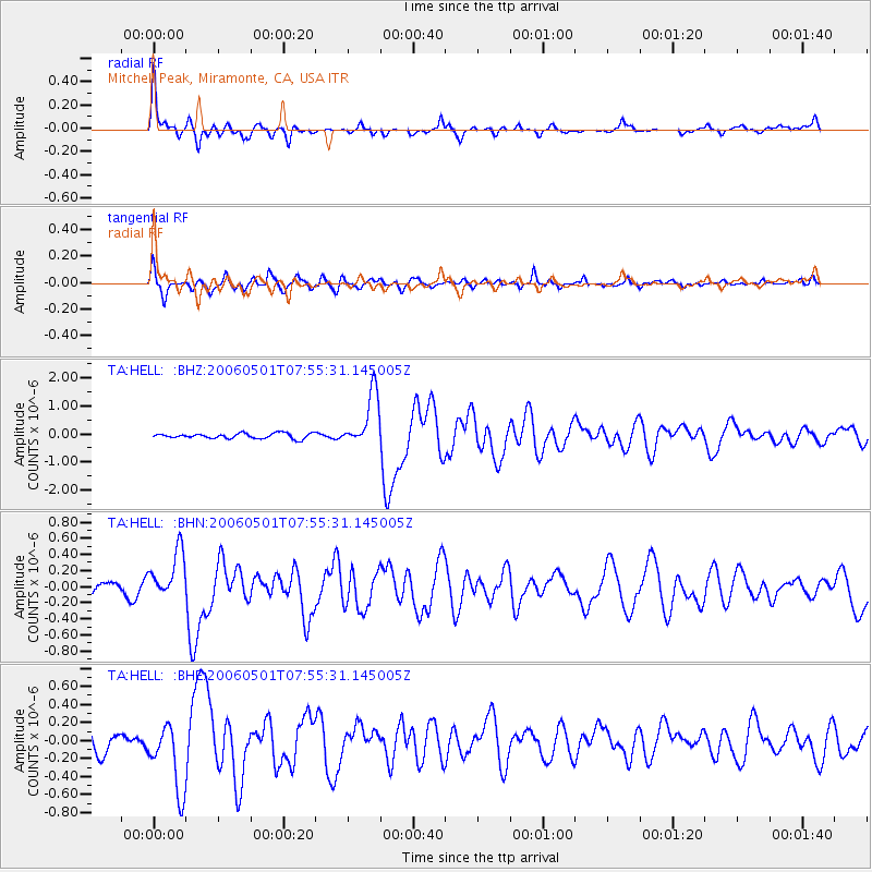
Signal To Noise
| Channel | StoN | STA | LTA |
| TA:HELL: :BHN:20060501T07:55:31.145005Z | 3.84293 | 3.027996E-7 | 7.879394E-8 |
| TA:HELL: :BHE:20060501T07:55:31.145005Z | 3.0159798 | 3.7862822E-7 | 1.255407E-7 |
| TA:HELL: :BHZ:20060501T07:55:31.145005Z | 10.512209 | 9.682967E-7 | 9.2111634E-8 |
| Arrivals |
| Ps | 1.6 SECOND |
| PpPs | 5.5 SECOND |
| PsPs/PpSs | 7.1 SECOND |


