You are here: Home > Network List > TA - USArray Transportable Network (new EarthScope stations) Stations List
> Station HELL Mitchell Peak, Miramonte, CA, USA > Earthquake Result Viewer
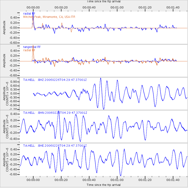
HELL Mitchell Peak, Miramonte, CA, USA - Earthquake Result Viewer

| Earthquake location: |
Fiji Islands Region |
| Earthquake latitude/longitude: |
-15.3/-176.2 |
| Earthquake time(UTC): |
2006/02/26 (057) 04:18:42 GMT |
| Earthquake Depth: |
32 km |
| Earthquake Magnitude: |
5.5 MB, 5.9 MS, 6.0 MW, 6.0 MW |
| Earthquake Catalog/Contributor: |
WHDF/NEIC |
|
| Network: |
TA USArray Transportable Network (new EarthScope stations) |
| Station: |
HELL Mitchell Peak, Miramonte, CA, USA |
| Lat/Lon: |
36.68 N/119.02 W |
| Elevation: |
1145 m |
|
| Distance: |
74.7 deg |
| Az: |
44.489 deg |
| Baz: |
237.275 deg |
| Ray Param: |
0.05212743 |
| Estimated Moho Depth: |
23.5 km |
| Estimated Crust Vp/Vs: |
2.10 |
| Assumed Crust Vp: |
6.291 km/s |
| Estimated Crust Vs: |
2.999 km/s |
| Estimated Crust Poisson's Ratio: |
0.35 |
|
| Radial Match: |
81.77855 % |
| Radial Bump: |
370 |
| Transverse Match: |
55.040485 % |
| Transverse Bump: |
400 |
| SOD ConfigId: |
132717 |
| Insert Time: |
2010-03-07 04:20:25.312 +0000 |
| GWidth: |
2.5 |
| Max Bumps: |
400 |
| Tol: |
0.001 |
|
Signal To Noise
| Channel | StoN | STA | LTA |
| TA:HELL: :BHN:20060226T04:29:47.37001Z | 0.93438035 | 1.2601676E-7 | 1.3486667E-7 |
| TA:HELL: :BHE:20060226T04:29:47.37001Z | 0.88471484 | 1.2512943E-7 | 1.4143475E-7 |
| TA:HELL: :BHZ:20060226T04:29:47.37001Z | 2.6046329 | 2.2400737E-7 | 8.600343E-8 |
| Arrivals |
| Ps | 4.2 SECOND |
| PpPs | 11 SECOND |
| PsPs/PpSs | 15 SECOND |


