You are here: Home > Network List > TA - USArray Transportable Network (new EarthScope stations) Stations List
> Station HELL Mitchell Peak, Miramonte, CA, USA > Earthquake Result Viewer
HELL Mitchell Peak, Miramonte, CA, USA - Earthquake Result Viewer
| Earthquake location: |
Vanuatu Islands |
| Earthquake latitude/longitude: |
-20.6/169.4 |
| Earthquake time(UTC): |
2007/03/25 (084) 00:40:01 GMT |
| Earthquake Depth: |
34 km |
| Earthquake Magnitude: |
6.5 MB, 7.0 MS, 7.1 MW, 7.1 MW |
| Earthquake Catalog/Contributor: |
WHDF/NEIC |
|
| Network: |
TA USArray Transportable Network (new EarthScope stations) |
| Station: |
HELL Mitchell Peak, Miramonte, CA, USA |
| Lat/Lon: |
36.68 N/119.02 W |
| Elevation: |
1145 m |
|
| Distance: |
88.3 deg |
| Az: |
49.749 deg |
| Baz: |
242.789 deg |
| Ray Param: |
0.042626854 |
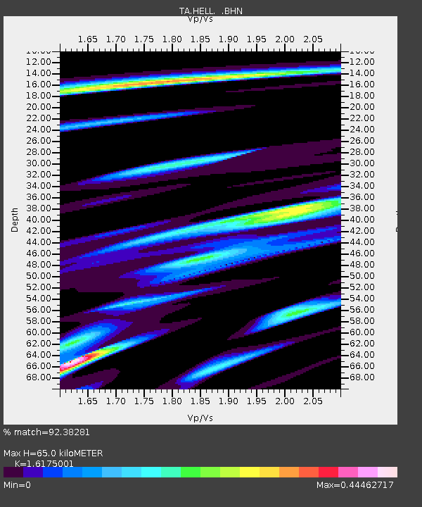
| Estimated Moho Depth: |
65.0 km |
| Estimated Crust Vp/Vs: |
1.62 |
| Assumed Crust Vp: |
6.291 km/s |
| Estimated Crust Vs: |
3.889 km/s |
| Estimated Crust Poisson's Ratio: |
0.19 |
|
| Radial Match: |
92.38281 % |
| Radial Bump: |
382 |
| Transverse Match: |
75.70683 % |
| Transverse Bump: |
400 |
| SOD ConfigId: |
2564 |
| Insert Time: |
2010-03-07 04:20:57.964 +0000 |
| GWidth: |
2.5 |
| Max Bumps: |
400 |
| Tol: |
0.001 |
|
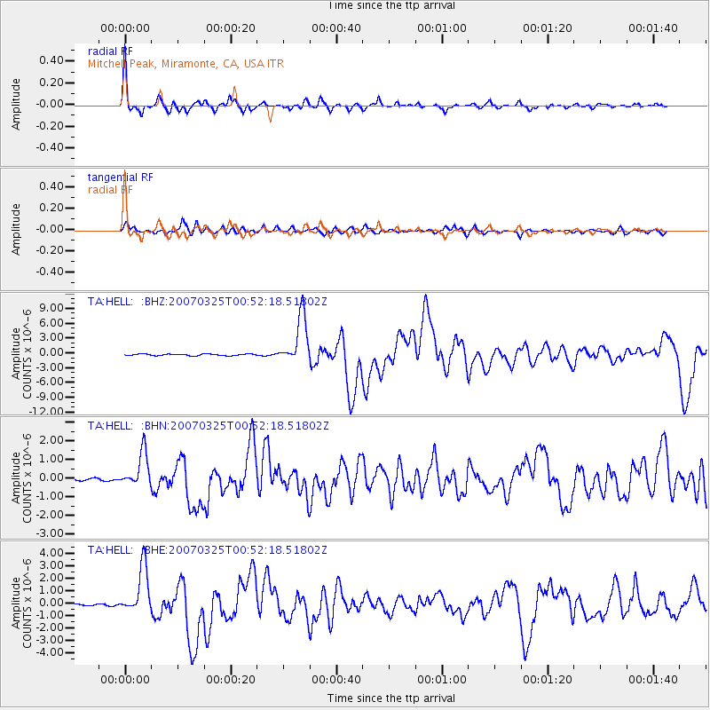
Signal To Noise
| Channel | StoN | STA | LTA |
| TA:HELL: :BHN:20070325T00:52:18.51802Z | 9.367936 | 9.4184156E-7 | 1.00538855E-7 |
| TA:HELL: :BHE:20070325T00:52:18.51802Z | 26.690792 | 1.9431352E-6 | 7.2801704E-8 |
| TA:HELL: :BHZ:20070325T00:52:18.51802Z | 31.020224 | 5.027894E-6 | 1.6208439E-7 |
| Arrivals |
| Ps | 6.5 SECOND |
| PpPs | 26 SECOND |
| PsPs/PpSs | 33 SECOND |


