You are here: Home > Network List > TA - USArray Transportable Network (new EarthScope stations) Stations List
> Station E20K Nigu River, AK, USA > Earthquake Result Viewer
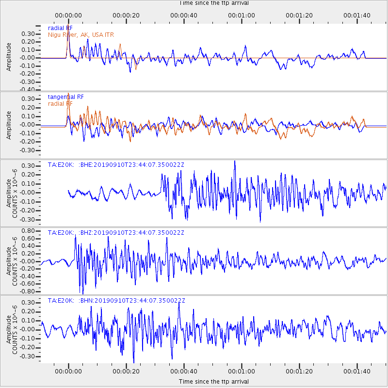
E20K Nigu River, AK, USA - Earthquake Result Viewer
*The percent match for this event was below the threshold and hence no stack was calculated.
| Earthquake location: |
Talaud Islands, Indonesia |
| Earthquake latitude/longitude: |
4.0/126.7 |
| Earthquake time(UTC): |
2019/09/10 (253) 23:32:23 GMT |
| Earthquake Depth: |
24 km |
| Earthquake Magnitude: |
5.6 Mww |
| Earthquake Catalog/Contributor: |
NEIC PDE/us |
|
| Network: |
TA USArray Transportable Network (new EarthScope stations) |
| Station: |
E20K Nigu River, AK, USA |
| Lat/Lon: |
68.26 N/156.19 W |
| Elevation: |
866 m |
|
| Distance: |
81.5 deg |
| Az: |
21.544 deg |
| Baz: |
259.487 deg |
| Ray Param: |
$rayparam |
*The percent match for this event was below the threshold and hence was not used in the summary stack. |
|
| Radial Match: |
69.573875 % |
| Radial Bump: |
400 |
| Transverse Match: |
58.314636 % |
| Transverse Bump: |
400 |
| SOD ConfigId: |
19053131 |
| Insert Time: |
2019-09-24 23:36:10.718 +0000 |
| GWidth: |
2.5 |
| Max Bumps: |
400 |
| Tol: |
0.001 |
|
Signal To Noise
| Channel | StoN | STA | LTA |
| TA:E20K: :BHZ:20190910T23:44:07.350022Z | 4.0029445 | 2.9025813E-7 | 7.251115E-8 |
| TA:E20K: :BHN:20190910T23:44:07.350022Z | 1.077208 | 5.9051708E-8 | 5.481922E-8 |
| TA:E20K: :BHE:20190910T23:44:07.350022Z | 2.2624228 | 9.249494E-8 | 4.0883137E-8 |
| Arrivals |
| Ps | |
| PpPs | |
| PsPs/PpSs | |


