You are here: Home > Network List > TA - USArray Transportable Network (new EarthScope stations) Stations List
> Station F20K Avaraart Lake, AK, USA > Earthquake Result Viewer
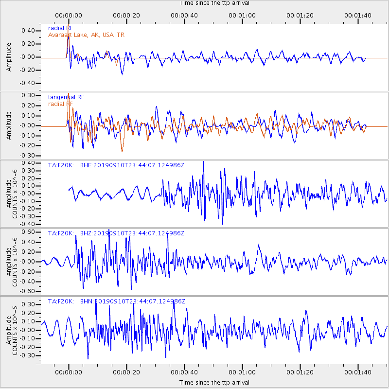
F20K Avaraart Lake, AK, USA - Earthquake Result Viewer
*The percent match for this event was below the threshold and hence no stack was calculated.
| Earthquake location: |
Talaud Islands, Indonesia |
| Earthquake latitude/longitude: |
4.0/126.7 |
| Earthquake time(UTC): |
2019/09/10 (253) 23:32:23 GMT |
| Earthquake Depth: |
24 km |
| Earthquake Magnitude: |
5.6 Mww |
| Earthquake Catalog/Contributor: |
NEIC PDE/us |
|
| Network: |
TA USArray Transportable Network (new EarthScope stations) |
| Station: |
F20K Avaraart Lake, AK, USA |
| Lat/Lon: |
67.05 N/155.73 W |
| Elevation: |
136 m |
|
| Distance: |
81.5 deg |
| Az: |
22.784 deg |
| Baz: |
260.098 deg |
| Ray Param: |
$rayparam |
*The percent match for this event was below the threshold and hence was not used in the summary stack. |
|
| Radial Match: |
64.25566 % |
| Radial Bump: |
400 |
| Transverse Match: |
59.36293 % |
| Transverse Bump: |
400 |
| SOD ConfigId: |
19053131 |
| Insert Time: |
2019-09-24 23:36:17.014 +0000 |
| GWidth: |
2.5 |
| Max Bumps: |
400 |
| Tol: |
0.001 |
|
Signal To Noise
| Channel | StoN | STA | LTA |
| TA:F20K: :BHZ:20190910T23:44:07.124986Z | 4.4742084 | 1.9884101E-7 | 4.4441606E-8 |
| TA:F20K: :BHN:20190910T23:44:07.124986Z | 2.3559275 | 1.1566075E-7 | 4.9093508E-8 |
| TA:F20K: :BHE:20190910T23:44:07.124986Z | 1.8273737 | 8.206081E-8 | 4.4906415E-8 |
| Arrivals |
| Ps | |
| PpPs | |
| PsPs/PpSs | |


