You are here: Home > Network List > AZ - ANZA Regional Network Stations List
> Station KNW AZ.KNW > Earthquake Result Viewer
KNW AZ.KNW - Earthquake Result Viewer
| Earthquake location: |
South Of Fiji Islands |
| Earthquake latitude/longitude: |
-25.6/178.3 |
| Earthquake time(UTC): |
2019/09/11 (254) 17:51:54 GMT |
| Earthquake Depth: |
599 km |
| Earthquake Magnitude: |
5.5 Mww |
| Earthquake Catalog/Contributor: |
NEIC PDE/us |
|
| Network: |
AZ ANZA Regional Network |
| Station: |
KNW AZ.KNW |
| Lat/Lon: |
33.71 N/116.71 W |
| Elevation: |
1507 m |
|
| Distance: |
85.3 deg |
| Az: |
49.267 deg |
| Baz: |
235.187 deg |
| Ray Param: |
0.043093137 |
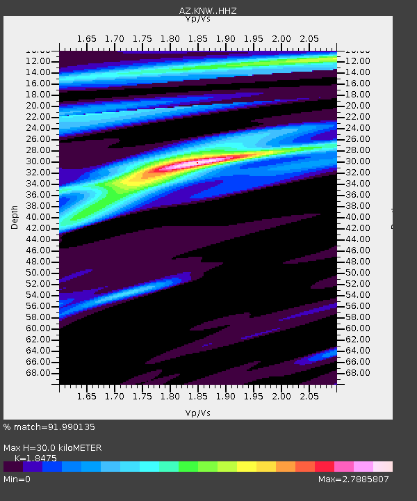
| Estimated Moho Depth: |
30.0 km |
| Estimated Crust Vp/Vs: |
1.85 |
| Assumed Crust Vp: |
6.264 km/s |
| Estimated Crust Vs: |
3.39 km/s |
| Estimated Crust Poisson's Ratio: |
0.29 |
|
| Radial Match: |
91.990135 % |
| Radial Bump: |
236 |
| Transverse Match: |
95.17947 % |
| Transverse Bump: |
217 |
| SOD ConfigId: |
19053131 |
| Insert Time: |
2019-09-25 17:56:38.939 +0000 |
| GWidth: |
2.5 |
| Max Bumps: |
400 |
| Tol: |
0.001 |
|
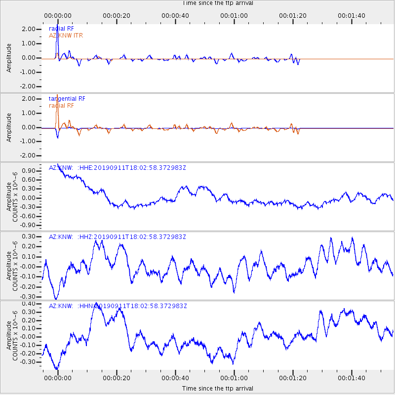
Signal To Noise
| Channel | StoN | STA | LTA |
| AZ:KNW: :HHZ:20190911T18:02:58.372983Z | 1.3831388 | 3.358749E-7 | 2.4283528E-7 |
| AZ:KNW: :HHN:20190911T18:02:58.372983Z | 1.3305503 | 5.1535324E-7 | 3.8732335E-7 |
| AZ:KNW: :HHE:20190911T18:02:58.372983Z | 1.1670294 | 4.6760508E-7 | 4.0067977E-7 |
| Arrivals |
| Ps | 4.1 SECOND |
| PpPs | 13 SECOND |
| PsPs/PpSs | 18 SECOND |


