You are here: Home > Network List > TA - USArray Transportable Network (new EarthScope stations) Stations List
> Station I17K Unalakleet, AK, USA > Earthquake Result Viewer
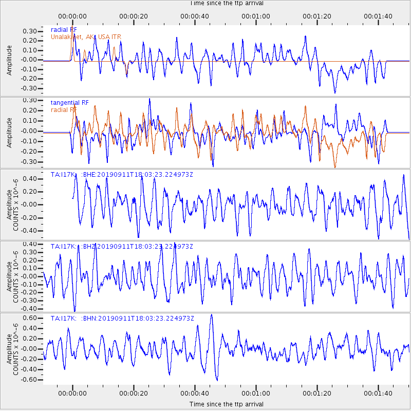
I17K Unalakleet, AK, USA - Earthquake Result Viewer
*The percent match for this event was below the threshold and hence no stack was calculated.
| Earthquake location: |
South Of Fiji Islands |
| Earthquake latitude/longitude: |
-25.6/178.3 |
| Earthquake time(UTC): |
2019/09/11 (254) 17:51:54 GMT |
| Earthquake Depth: |
599 km |
| Earthquake Magnitude: |
5.5 Mww |
| Earthquake Catalog/Contributor: |
NEIC PDE/us |
|
| Network: |
TA USArray Transportable Network (new EarthScope stations) |
| Station: |
I17K Unalakleet, AK, USA |
| Lat/Lon: |
63.89 N/160.70 W |
| Elevation: |
105 m |
|
| Distance: |
90.7 deg |
| Az: |
9.12 deg |
| Baz: |
198.873 deg |
| Ray Param: |
$rayparam |
*The percent match for this event was below the threshold and hence was not used in the summary stack. |
|
| Radial Match: |
46.183666 % |
| Radial Bump: |
400 |
| Transverse Match: |
47.97251 % |
| Transverse Bump: |
400 |
| SOD ConfigId: |
19053131 |
| Insert Time: |
2019-09-25 17:59:32.720 +0000 |
| GWidth: |
2.5 |
| Max Bumps: |
400 |
| Tol: |
0.001 |
|
Signal To Noise
| Channel | StoN | STA | LTA |
| TA:I17K: :BHZ:20190911T18:03:23.224973Z | 1.6891761 | 2.0804012E-7 | 1.231607E-7 |
| TA:I17K: :BHN:20190911T18:03:23.224973Z | 1.2673864 | 1.6952323E-7 | 1.3375814E-7 |
| TA:I17K: :BHE:20190911T18:03:23.224973Z | 0.9266207 | 2.0215879E-7 | 2.1816778E-7 |
| Arrivals |
| Ps | |
| PpPs | |
| PsPs/PpSs | |


