You are here: Home > Network List > US - United States National Seismic Network Stations List
> Station WMOK Wichita Mountains, Oklahoma, USA > Earthquake Result Viewer
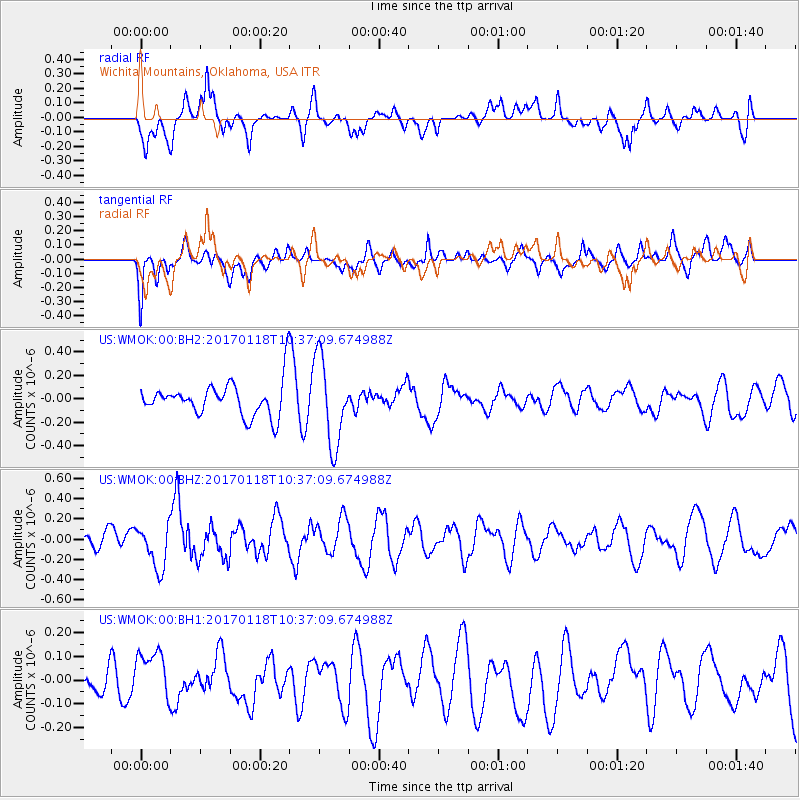
WMOK Wichita Mountains, Oklahoma, USA - Earthquake Result Viewer
*The percent match for this event was below the threshold and hence no stack was calculated.
| Earthquake location: |
Central Italy |
| Earthquake latitude/longitude: |
42.6/13.2 |
| Earthquake time(UTC): |
2017/01/18 (018) 10:25:25 GMT |
| Earthquake Depth: |
10 km |
| Earthquake Magnitude: |
5.6 Mww |
| Earthquake Catalog/Contributor: |
NEIC PDE/us |
|
| Network: |
US United States National Seismic Network |
| Station: |
WMOK Wichita Mountains, Oklahoma, USA |
| Lat/Lon: |
34.74 N/98.78 W |
| Elevation: |
486 m |
|
| Distance: |
81.1 deg |
| Az: |
309.393 deg |
| Baz: |
43.857 deg |
| Ray Param: |
$rayparam |
*The percent match for this event was below the threshold and hence was not used in the summary stack. |
|
| Radial Match: |
43.872707 % |
| Radial Bump: |
400 |
| Transverse Match: |
52.031628 % |
| Transverse Bump: |
400 |
| SOD ConfigId: |
1943534 |
| Insert Time: |
2017-02-01 10:34:09.923 +0000 |
| GWidth: |
2.5 |
| Max Bumps: |
400 |
| Tol: |
0.001 |
|
Signal To Noise
| Channel | StoN | STA | LTA |
| US:WMOK:00:BHZ:20170118T10:37:09.674988Z | 2.631343 | 2.1685582E-7 | 8.2412605E-8 |
| US:WMOK:00:BH1:20170118T10:37:09.674988Z | 0.79011613 | 1.07082954E-7 | 1.3552811E-7 |
| US:WMOK:00:BH2:20170118T10:37:09.674988Z | 2.5606165 | 3.7004142E-7 | 1.4451263E-7 |
| Arrivals |
| Ps | |
| PpPs | |
| PsPs/PpSs | |


